
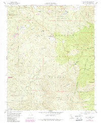
~ Lake Fulmor CA topo map, 1:24000 scale, 7.5 X 7.5 Minute, Historical, 1956, updated 1988
Lake Fulmor, California, USGS topographic map dated 1956.
Includes geographic coordinates (latitude and longitude). This topographic map is suitable for hiking, camping, and exploring, or framing it as a wall map.
Printed on-demand using high resolution imagery, on heavy weight and acid free paper, or alternatively on a variety of synthetic materials.
Topos available on paper, Waterproof, Poly, or Tyvek. Usually shipping rolled, unless combined with other folded maps in one order.
- Product Number: USGS-5516841
- Free digital map download (high-resolution, GeoPDF): Lake Fulmor, California (file size: 15 MB)
- Map Size: please refer to the dimensions of the GeoPDF map above
- Weight (paper map): ca. 55 grams
- Map Type: POD USGS Topographic Map
- Map Series: HTMC
- Map Verison: Historical
- Cell ID: 70622
- Scan ID: 292068
- Imprint Year: 1988
- Woodland Tint: Yes
- Photo Revision Year: 1988
- Aerial Photo Year: 1985
- Edit Year: 1988
- Field Check Year: 1956
- Datum: NAD27
- Map Projection: Polyconic
- Map published by United States Geological Survey
- Map Language: English
- Scanner Resolution: 600 dpi
- Map Cell Name: Lake Fulmor
- Grid size: 7.5 X 7.5 Minute
- Date on map: 1956
- Map Scale: 1:24000
- Geographical region: California, United States
Neighboring Maps:
All neighboring USGS topo maps are available for sale online at a variety of scales.
Spatial coverage:
Topo map Lake Fulmor, California, covers the geographical area associated the following places:
- Pigeon Spring - Peach Tree Spring - Mellor Ranch - Oak Spring - Hall Mill 826 Dam - Indian Creek Truck Trail - Oak Flat - Black Mountain Trail - Lake Fulmor Picnic Area - Black Mountain Scenic Area - Fawn Spring - Lake Fulmor - Bee Canyon Truck Trail - Point View - San Jacinto Ridge Truck Trail - Ditch Creek - Ranger Peak Lookout - Black Mountain Truck Trail - Black Mountain - Alandale Forest Service Facility - Twin Pines Ranch - Black Mountain Creek - Cinco Poses Trail - Cave Spring - Azalea Creek - Bay Tree Spring - Stone Creek Campground - Indian Mountain - Trailfinders Camp - Boulder Basin Group - Hall Canyon - Chappel Ranch - Poppet Flat Divide Truck Trail - Angelus Hill - Riverside County Fire Department Station 63 - Poppet Flats - Browns Ranch - Mount Oak Boys Ranch - Halldecker Campground - Hungry Hollow - Cinco Poses Spring - Vista Grande Guard Station - Hurley Flat - Ranger Peak - Stone Creek - Metate Flat - Buck Spring - Poppet Flat - Logan Creek - Mellor Creek - McMullen Flat
- Map Area ID: AREA33.87533.75-116.875-116.75
- Northwest corner Lat/Long code: USGSNW33.875-116.875
- Northeast corner Lat/Long code: USGSNE33.875-116.75
- Southwest corner Lat/Long code: USGSSW33.75-116.875
- Southeast corner Lat/Long code: USGSSE33.75-116.75
- Northern map edge Latitude: 33.875
- Southern map edge Latitude: 33.75
- Western map edge Longitude: -116.875
- Eastern map edge Longitude: -116.75


