
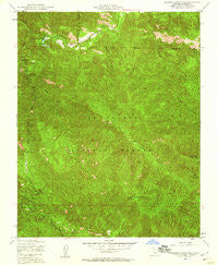
~ Junipero Serra Peak CA topo map, 1:24000 scale, 7.5 X 7.5 Minute, Historical, 1949, updated 1960
Junipero Serra Peak, California, USGS topographic map dated 1949.
Includes geographic coordinates (latitude and longitude). This topographic map is suitable for hiking, camping, and exploring, or framing it as a wall map.
Printed on-demand using high resolution imagery, on heavy weight and acid free paper, or alternatively on a variety of synthetic materials.
Topos available on paper, Waterproof, Poly, or Tyvek. Usually shipping rolled, unless combined with other folded maps in one order.
- Product Number: USGS-5516279
- Free digital map download (high-resolution, GeoPDF): Junipero Serra Peak, California (file size: 21 MB)
- Map Size: please refer to the dimensions of the GeoPDF map above
- Weight (paper map): ca. 55 grams
- Map Type: POD USGS Topographic Map
- Map Series: HTMC
- Map Verison: Historical
- Cell ID: 22952
- Scan ID: 291765
- Imprint Year: 1960
- Woodland Tint: Yes
- Aerial Photo Year: 1947
- Field Check Year: 1949
- Datum: NAD27
- Map Projection: Polyconic
- Map published by United States Geological Survey
- Map published by United States Army Corps of Engineers
- Map published by United States Army
- Map Language: English
- Scanner Resolution: 600 dpi
- Map Cell Name: Junipero Serra Peak
- Grid size: 7.5 X 7.5 Minute
- Date on map: 1949
- Map Scale: 1:24000
- Geographical region: California, United States
Neighboring Maps:
All neighboring USGS topo maps are available for sale online at a variety of scales.
Spatial coverage:
Topo map Junipero Serra Peak, California, covers the geographical area associated the following places:
- Arroyo Seco Recreation Site - Escondido Camp Ground - South Fork Santa Lucia Creek - Junipero Serra Peak - Rocky Creek - Pinyon Peak - Woodtick Canyon - Horse Run - Hanging Valley Campground - Santa Lucia Creek - Bear Mountain - South Monterey County Fire Protection District Arroyo Seco Fire Station - Arroyo Seco Recreation Site - Abbott Ranch - Abbott Lakes - Rancho Escondido (historical) - Last Chance Rustic Campsite - Girl Scout Camp
- Map Area ID: AREA36.2536.125-121.5-121.375
- Northwest corner Lat/Long code: USGSNW36.25-121.5
- Northeast corner Lat/Long code: USGSNE36.25-121.375
- Southwest corner Lat/Long code: USGSSW36.125-121.5
- Southeast corner Lat/Long code: USGSSE36.125-121.375
- Northern map edge Latitude: 36.25
- Southern map edge Latitude: 36.125
- Western map edge Longitude: -121.5
- Eastern map edge Longitude: -121.375


