
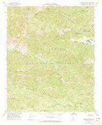
~ Hurricane Deck CA topo map, 1:24000 scale, 7.5 X 7.5 Minute, Historical, 1964, updated 1965
Hurricane Deck, California, USGS topographic map dated 1964.
Includes geographic coordinates (latitude and longitude). This topographic map is suitable for hiking, camping, and exploring, or framing it as a wall map.
Printed on-demand using high resolution imagery, on heavy weight and acid free paper, or alternatively on a variety of synthetic materials.
Topos available on paper, Waterproof, Poly, or Tyvek. Usually shipping rolled, unless combined with other folded maps in one order.
- Product Number: USGS-5515793
- Free digital map download (high-resolution, GeoPDF): Hurricane Deck, California (file size: 18 MB)
- Map Size: please refer to the dimensions of the GeoPDF map above
- Weight (paper map): ca. 55 grams
- Map Type: POD USGS Topographic Map
- Map Series: HTMC
- Map Verison: Historical
- Cell ID: 21580
- Scan ID: 291508
- Imprint Year: 1965
- Woodland Tint: Yes
- Aerial Photo Year: 1953
- Field Check Year: 1964
- Datum: NAD27
- Map Projection: Polyconic
- Map published by United States Geological Survey
- Map Language: English
- Scanner Resolution: 600 dpi
- Map Cell Name: Hurricane Deck
- Grid size: 7.5 X 7.5 Minute
- Date on map: 1964
- Map Scale: 1:24000
- Geographical region: California, United States
Neighboring Maps:
All neighboring USGS topo maps are available for sale online at a variety of scales.
Spatial coverage:
Topo map Hurricane Deck, California, covers the geographical area associated the following places:
- Ernest Blanco Spring - Upper Branch Canyon Spring - Jackson Trail - Big Bend Canyon - Cuyama Division - Hurricane Deck - South Fork Rustic Campsite - Upper Trough Canyon Spring - Manzana Trail - Abel Canyon - East Mine Canyon Spring - Live Oak Spring - South Fork Sisquoc River - Lost Knife Spring - Montgomery Number Two Spring - Happy Hunting Ground Campground - Montgomery Number Three Spring - Abel Canyon Spring - North Mine Canyon Spring - Black Willow Spring - South Fork Guard Station - Mine Canyon - Montgomery Potrero - White Ledge Campground - Sweetwater Canyon - Jackson Spring - White Ledge Canyon - Abel Canyon Campground - Hurricane Deck Trail - Foresters Leap Canyon - Lonnie Davis Campground - San Rafael Wilderness - Cliff Campground - Painted Rock Campground - Sycamore Campground - Montgomery Spring
- Map Area ID: AREA34.87534.75-119.875-119.75
- Northwest corner Lat/Long code: USGSNW34.875-119.875
- Northeast corner Lat/Long code: USGSNE34.875-119.75
- Southwest corner Lat/Long code: USGSSW34.75-119.875
- Southeast corner Lat/Long code: USGSSE34.75-119.75
- Northern map edge Latitude: 34.875
- Southern map edge Latitude: 34.75
- Western map edge Longitude: -119.875
- Eastern map edge Longitude: -119.75


