
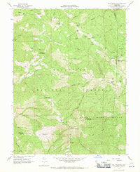
~ Hull Mountain CA topo map, 1:24000 scale, 7.5 X 7.5 Minute, Historical, 1967, updated 1970
Hull Mountain, California, USGS topographic map dated 1967.
Includes geographic coordinates (latitude and longitude). This topographic map is suitable for hiking, camping, and exploring, or framing it as a wall map.
Printed on-demand using high resolution imagery, on heavy weight and acid free paper, or alternatively on a variety of synthetic materials.
Topos available on paper, Waterproof, Poly, or Tyvek. Usually shipping rolled, unless combined with other folded maps in one order.
- Product Number: USGS-5515731
- Free digital map download (high-resolution, GeoPDF): Hull Mountain, California (file size: 13 MB)
- Map Size: please refer to the dimensions of the GeoPDF map above
- Weight (paper map): ca. 55 grams
- Map Type: POD USGS Topographic Map
- Map Series: HTMC
- Map Verison: Historical
- Cell ID: 21425
- Scan ID: 291475
- Imprint Year: 1970
- Woodland Tint: Yes
- Aerial Photo Year: 1965
- Field Check Year: 1967
- Datum: NAD27
- Map Projection: Polyconic
- Map published by United States Geological Survey
- Map Language: English
- Scanner Resolution: 600 dpi
- Map Cell Name: Hull Mountain
- Grid size: 7.5 X 7.5 Minute
- Date on map: 1967
- Map Scale: 1:24000
- Geographical region: California, United States
Neighboring Maps:
All neighboring USGS topo maps are available for sale online at a variety of scales.
Spatial coverage:
Topo map Hull Mountain, California, covers the geographical area associated the following places:
- Goat Rock - Calamese Rock - Bean Rock - Wesley Ives Creek - Goat Camp - Yuki Wilderness - Mendenhall Camp - Hull Mountain - Windy Point - Cherry Hill - Hull Creek - Windy Gap - Hulls Grave - Chipmunk Spring - Millsap Cabin (historical) - Pole Point - Panther Rock - Millsap Cabin - Graves Cabin - Tar Flat Forest Service Facility - Tar Flat - Spruce Grove Campground - Red Rock - Cushman Lake - Red Rock Ridge - Monkey Rock - Panther Ridge - Hells Half Acre - Timberline Camp - Bald Mountain - Cushman Camp - Booth Crossing - Devils Rock Garden - Little Bear Rock - Barley Lake - Big Spring - Horse Ridge - Swallow Rock - Appletree Spring - Lee Logan Camp - Hull Mountain Lookout
- Map Area ID: AREA39.62539.5-123-122.875
- Northwest corner Lat/Long code: USGSNW39.625-123
- Northeast corner Lat/Long code: USGSNE39.625-122.875
- Southwest corner Lat/Long code: USGSSW39.5-123
- Southeast corner Lat/Long code: USGSSE39.5-122.875
- Northern map edge Latitude: 39.625
- Southern map edge Latitude: 39.5
- Western map edge Longitude: -123
- Eastern map edge Longitude: -122.875


