
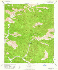
~ Hildreth Peak CA topo map, 1:24000 scale, 7.5 X 7.5 Minute, Historical, 1943, updated 1963
Hildreth Peak, California, USGS topographic map dated 1943.
Includes geographic coordinates (latitude and longitude). This topographic map is suitable for hiking, camping, and exploring, or framing it as a wall map.
Printed on-demand using high resolution imagery, on heavy weight and acid free paper, or alternatively on a variety of synthetic materials.
Topos available on paper, Waterproof, Poly, or Tyvek. Usually shipping rolled, unless combined with other folded maps in one order.
- Product Number: USGS-5515459
- Free digital map download (high-resolution, GeoPDF): Hildreth Peak, California (file size: 17 MB)
- Map Size: please refer to the dimensions of the GeoPDF map above
- Weight (paper map): ca. 55 grams
- Map Type: POD USGS Topographic Map
- Map Series: HTMC
- Map Verison: Historical
- Cell ID: 20432
- Scan ID: 291333
- Imprint Year: 1963
- Woodland Tint: Yes
- Aerial Photo Year: 1942
- Datum: NAD27
- Map Projection: Polyconic
- Map published by United States Army Corps of Engineers
- Map published by United States Department of War
- Map Language: English
- Scanner Resolution: 600 dpi
- Map Cell Name: Hildreth Peak
- Grid size: 7.5 X 7.5 Minute
- Date on map: 1943
- Map Scale: 1:24000
- Geographical region: California, United States
Neighboring Maps:
All neighboring USGS topo maps are available for sale online at a variety of scales.
Spatial coverage:
Topo map Hildreth Peak, California, covers the geographical area associated the following places:
- Pendola Campground - Big Caliente Recreation Site - Ogilvy Ranch - Diablo Canyon - Mono Alamar Trail - East Fork Diablo Canyon - Hildreth Peak - Little Caliente Spring - Roblar Trail - The Narrows - Agua Caliente Canyon - Pendola Debris Dam - P-Bar Flats Campground - Alamar Canyon - Big Caliente Debris Dam - Big Cliente Debris Dam - Agua Caliente Trail - Pie Canyon - Lower Caliente Recreation Site - Roblar Canyon - Middle Santa Ynez Campground - Horse Canyon - Blue Canyon - Pendola Guard Station - Agua Caliente Spring - P-Bar Flats - Rose Canyon
- Map Area ID: AREA34.62534.5-119.625-119.5
- Northwest corner Lat/Long code: USGSNW34.625-119.625
- Northeast corner Lat/Long code: USGSNE34.625-119.5
- Southwest corner Lat/Long code: USGSSW34.5-119.625
- Southeast corner Lat/Long code: USGSSE34.5-119.5
- Northern map edge Latitude: 34.625
- Southern map edge Latitude: 34.5
- Western map edge Longitude: -119.625
- Eastern map edge Longitude: -119.5


