
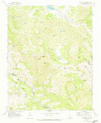
~ Hepsedam Peak CA topo map, 1:24000 scale, 7.5 X 7.5 Minute, Historical, 1969, updated 1973
Hepsedam Peak, California, USGS topographic map dated 1969.
Includes geographic coordinates (latitude and longitude). This topographic map is suitable for hiking, camping, and exploring, or framing it as a wall map.
Printed on-demand using high resolution imagery, on heavy weight and acid free paper, or alternatively on a variety of synthetic materials.
Topos available on paper, Waterproof, Poly, or Tyvek. Usually shipping rolled, unless combined with other folded maps in one order.
- Product Number: USGS-5515367
- Free digital map download (high-resolution, GeoPDF): Hepsedam Peak, California (file size: 12 MB)
- Map Size: please refer to the dimensions of the GeoPDF map above
- Weight (paper map): ca. 55 grams
- Map Type: POD USGS Topographic Map
- Map Series: HTMC
- Map Verison: Historical
- Cell ID: 20147
- Scan ID: 291283
- Imprint Year: 1973
- Woodland Tint: Yes
- Aerial Photo Year: 1967
- Field Check Year: 1969
- Datum: NAD27
- Map Projection: Polyconic
- Map published by United States Geological Survey
- Map Language: English
- Scanner Resolution: 600 dpi
- Map Cell Name: Hepsedam Peak
- Grid size: 7.5 X 7.5 Minute
- Date on map: 1969
- Map Scale: 1:24000
- Geographical region: California, United States
Neighboring Maps:
All neighboring USGS topo maps are available for sale online at a variety of scales.
Spatial coverage:
Topo map Hepsedam Peak, California, covers the geographical area associated the following places:
- Dunham Spring - Augustine Creek - Orejano Spring - James Canyon - Kenner Lake - Panther Peak - Kenneth Cabin - Sweetwater Spring - Dry Lake - Sulphur Canyon - Bootleg Spring - Airstrip Pond - Susie Spring - Calhoon Cabin - Hepsedam Ranch - Laguna Lake - Laguna Mountain - Rattlesnake Gulch - Badlands - Split Rock - Abelardo Cabin - Miller Canyon - Hog Hole - John Cabin - Hernandez Valley - Spanish Flats - Garcia Creek - Hernandez School (historical) - Byles Canyon - Split Oak Spring - North Fork Oak Canyon - Lake Spring - Hepsedam Creek - Hepsedam Peak - Horsethief Canyon - Vasquez Rock - Hepsedam Spring - Laguna Ranch - Cedar Spring - Sulphur Spring - Orejano Flat - Clear Creek - Tucker Gulch - Mail Trail Pond - The Gorge - Gull Neck Rock - Bar B Ranch - Cottonwood Springs - Vasquez Crossing - Mail Trail
- Map Area ID: AREA36.37536.25-120.875-120.75
- Northwest corner Lat/Long code: USGSNW36.375-120.875
- Northeast corner Lat/Long code: USGSNE36.375-120.75
- Southwest corner Lat/Long code: USGSSW36.25-120.875
- Southeast corner Lat/Long code: USGSSE36.25-120.75
- Northern map edge Latitude: 36.375
- Southern map edge Latitude: 36.25
- Western map edge Longitude: -120.875
- Eastern map edge Longitude: -120.75


