
~ Frenchman Lake CA topo map, 1:24000 scale, 7.5 X 7.5 Minute, Historical, 1994, updated 1998
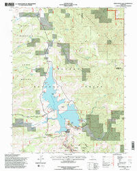
Frenchman Lake, California, USGS topographic map dated 1994.
Includes geographic coordinates (latitude and longitude). This topographic map is suitable for hiking, camping, and exploring, or framing it as a wall map.
Printed on-demand using high resolution imagery, on heavy weight and acid free paper, or alternatively on a variety of synthetic materials.
Topos available on paper, Waterproof, Poly, or Tyvek. Usually shipping rolled, unless combined with other folded maps in one order.
- Product Number: USGS-5514217
- Free digital map download (high-resolution, GeoPDF): Frenchman Lake, California (file size: 14 MB)
- Map Size: please refer to the dimensions of the GeoPDF map above
- Weight (paper map): ca. 55 grams
- Map Type: POD USGS Topographic Map
- Map Series: HTMC
- Map Verison: Historical
- Cell ID: 16437
- Scan ID: 102188
- Imprint Year: 1998
- Woodland Tint: Yes
- Visual Version Number: 1
- Aerial Photo Year: 1993
- Field Check Year: 1994
- Datum: NAD27
- Map Projection: Lambert Conformal Conic
- Map published by United States Geological Survey
- Map published by United States Forest Service
- Map Language: English
- Scanner Resolution: 600 dpi
- Map Cell Name: Frenchman Lake
- Grid size: 7.5 X 7.5 Minute
- Date on map: 1994
- Map Scale: 1:24000
- Geographical region: California, United States
Neighboring Maps:
All neighboring USGS topo maps are available for sale online at a variety of scales.
Spatial coverage:
Topo map Frenchman Lake, California, covers the geographical area associated the following places:
- Frenchman Dam - Grigsby Spring - Spring Creek - Camp Dixie - Big Cove Campground - Frenchman Creek - Cottonwood Spring Campground - Trosi Spring - Ramelli Creek - Galeppi Creek - South Fork Ramelli Creek - Frenchman Forest Service - Little Dooley Creek - Dotta Spring - Frenchman Lake - Lunker Point - Spring Creek Campground - Bloomer Lake - Grigsby Camp - Crystal Vista - Dooley Canyon - Frenchman Campground - North Fork Ramelli Creek - Grigsby Creek - Crystal - Lookout Creek - Frenchman 1-043 Dam - Last Chance Valley (historical) - Little Last Chance Canyon Scenic Area - Turkey Point - Dixie Spring - Dooley Canyon Spring
- Map Area ID: AREA4039.875-120.25-120.125
- Northwest corner Lat/Long code: USGSNW40-120.25
- Northeast corner Lat/Long code: USGSNE40-120.125
- Southwest corner Lat/Long code: USGSSW39.875-120.25
- Southeast corner Lat/Long code: USGSSE39.875-120.125
- Northern map edge Latitude: 40
- Southern map edge Latitude: 39.875
- Western map edge Longitude: -120.25
- Eastern map edge Longitude: -120.125


