
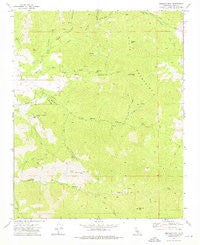
~ Emerald Mtn CA topo map, 1:24000 scale, 7.5 X 7.5 Minute, Historical, 1972, updated 1976
Emerald Mtn, California, USGS topographic map dated 1972.
Includes geographic coordinates (latitude and longitude). This topographic map is suitable for hiking, camping, and exploring, or framing it as a wall map.
Printed on-demand using high resolution imagery, on heavy weight and acid free paper, or alternatively on a variety of synthetic materials.
Topos available on paper, Waterproof, Poly, or Tyvek. Usually shipping rolled, unless combined with other folded maps in one order.
- Product Number: USGS-5513465
- Free digital map download (high-resolution, GeoPDF): Emerald Mtn, California (file size: 12 MB)
- Map Size: please refer to the dimensions of the GeoPDF map above
- Weight (paper map): ca. 55 grams
- Map Type: POD USGS Topographic Map
- Map Series: HTMC
- Map Verison: Historical
- Cell ID: 14271
- Scan ID: 290335
- Imprint Year: 1976
- Woodland Tint: Yes
- Aerial Photo Year: 1970
- Field Check Year: 1972
- Datum: NAD27
- Map Projection: Lambert Conformal Conic
- Map published by United States Geological Survey
- Map Language: English
- Scanner Resolution: 600 dpi
- Map Cell Name: Emerald Mountain
- Grid size: 7.5 X 7.5 Minute
- Date on map: 1972
- Map Scale: 1:24000
- Geographical region: California, United States
Neighboring Maps:
All neighboring USGS topo maps are available for sale online at a variety of scales.
Spatial coverage:
Topo map Emerald Mtn, California, covers the geographical area associated the following places:
- Arnold Ranch - Barrel Spring - Big Hart Canyon - Hart Canyon - Hugh Mann Canyon - Weldons Ranch - Emerald Mountain - Silver Creek - Hard Luck Mine - Weldon Peak - Fox Canyon - Mud Springs - Soda Springs - Hamp Williams Pass - Miller Springs - Miller Ranch (historical) - Antimony Ridge - Wooden Shoe Annies Ranch - Saddle Spring - Smith Canyon - Little Hart Canyon - Pine Spring - Nagel Canyon - Orejano Canyon - Mammoth Eureka Mines
- Map Area ID: AREA35.37535.25-118.375-118.25
- Northwest corner Lat/Long code: USGSNW35.375-118.375
- Northeast corner Lat/Long code: USGSNE35.375-118.25
- Southwest corner Lat/Long code: USGSSW35.25-118.375
- Southeast corner Lat/Long code: USGSSE35.25-118.25
- Northern map edge Latitude: 35.375
- Southern map edge Latitude: 35.25
- Western map edge Longitude: -118.375
- Eastern map edge Longitude: -118.25


