
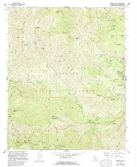
~ Chilao Flat CA topo map, 1:24000 scale, 7.5 X 7.5 Minute, Historical, 1959, updated 1994
Chilao Flat, California, USGS topographic map dated 1959.
Includes geographic coordinates (latitude and longitude). This topographic map is suitable for hiking, camping, and exploring, or framing it as a wall map.
Printed on-demand using high resolution imagery, on heavy weight and acid free paper, or alternatively on a variety of synthetic materials.
Topos available on paper, Waterproof, Poly, or Tyvek. Usually shipping rolled, unless combined with other folded maps in one order.
- Product Number: USGS-5510727
- Free digital map download (high-resolution, GeoPDF): Chilao Flat, California (file size: 17 MB)
- Map Size: please refer to the dimensions of the GeoPDF map above
- Weight (paper map): ca. 55 grams
- Map Type: POD USGS Topographic Map
- Map Series: HTMC
- Map Verison: Historical
- Cell ID: 8511
- Scan ID: 289177
- Imprint Year: 1994
- Woodland Tint: Yes
- Aerial Photo Year: 1957
- Edit Year: 1994
- Field Check Year: 1959
- Datum: NAD27
- Map Projection: Lambert Conformal Conic
- Map published by United States Geological Survey
- Map Language: English
- Scanner Resolution: 600 dpi
- Map Cell Name: Chilao Flat
- Grid size: 7.5 X 7.5 Minute
- Date on map: 1959
- Map Scale: 1:24000
- Geographical region: California, United States
Neighboring Maps:
All neighboring USGS topo maps are available for sale online at a variety of scales.
Spatial coverage:
Topo map Chilao Flat, California, covers the geographical area associated the following places:
- Middle Fork Mill Creek - Red Box Gap - East Fork Alder Creek - Grotto Creek - Ladybug Canyon - Horse Flats Campground - Colby Ranch - Valley Forge Lodge (historical) - Vetter Mountain - Valley Forge - Granite Mountain - Iron Mountain - Nike Site LA-09L (historical) - Rabbit Peak - Charlton Flat - Camp Hi-Hill - Bandido Campground - Red Box Station - Cloudburst Canyon - Gabrielino National Scenic Trail - Chilao Visitors Center - West Fork Alder Creek - Loomis Ranch - Mule Fork - Old Camp - Colby Bridge Day Use Area - Chilao Flat - Lynx Target Shooting Area - Monte Cristo Station - Mount Hillyer - Alder Saddle - Coldwater Canyon - Mount Mooney - Silver Moccasin Trail - Alder Creek - Wickiup Canyon - Camp Hidden Valley - Chilao Station - Wildcat Gulch - Black Cargo Mine - Cedar Canyon - Baughman Spring - Roundtop - Chilao Campground - Lynx Gulch - Camp Kole - Upper Big Tujunga Canyon - Charlton Flats Picnic Grounds - Monte Cristo Creek - Monte Cristo Mine - Horse Flats - Camp Rosenita - Trail Fork - Charlton Station - Middle Shooting Area - Barley Flats - Loomis Mine - Falcon Mine - Doe Spring - Chilao Creek - Mount Lawlor - Valley Forge Canyon - Falls Canyon - North Fork Alder Creek - Mill Creek Picnic Grounds - Shortcut Station - Middle Fork Alder Creek - Strawberry Peak - Newcomb Ranch - Gold Bar Mine - Mount Sally - Shortcut Picnic Grounds - Wickiup Campground - Black Crow Mine
- Map Area ID: AREA34.37534.25-118.125-118
- Northwest corner Lat/Long code: USGSNW34.375-118.125
- Northeast corner Lat/Long code: USGSNE34.375-118
- Southwest corner Lat/Long code: USGSSW34.25-118.125
- Southeast corner Lat/Long code: USGSSE34.25-118
- Northern map edge Latitude: 34.375
- Southern map edge Latitude: 34.25
- Western map edge Longitude: -118.125
- Eastern map edge Longitude: -118


