
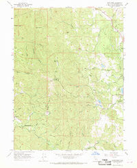
~ Cahto Peak CA topo map, 1:24000 scale, 7.5 X 7.5 Minute, Historical, 1967, updated 1969
Cahto Peak, California, USGS topographic map dated 1967.
Includes geographic coordinates (latitude and longitude). This topographic map is suitable for hiking, camping, and exploring, or framing it as a wall map.
Printed on-demand using high resolution imagery, on heavy weight and acid free paper, or alternatively on a variety of synthetic materials.
Topos available on paper, Waterproof, Poly, or Tyvek. Usually shipping rolled, unless combined with other folded maps in one order.
- Product Number: USGS-5509681
- Free digital map download (high-resolution, GeoPDF): Cahto Peak, California (file size: 12 MB)
- Map Size: please refer to the dimensions of the GeoPDF map above
- Weight (paper map): ca. 55 grams
- Map Type: POD USGS Topographic Map
- Map Series: HTMC
- Map Verison: Historical
- Cell ID: 6657
- Scan ID: 288745
- Imprint Year: 1969
- Woodland Tint: Yes
- Aerial Photo Year: 1964
- Field Check Year: 1967
- Datum: NAD27
- Map Projection: Polyconic
- Map published by United States Geological Survey
- Map Language: English
- Scanner Resolution: 600 dpi
- Map Cell Name: Cahto Peak
- Grid size: 7.5 X 7.5 Minute
- Date on map: 1967
- Map Scale: 1:24000
- Geographical region: California, United States
Neighboring Maps:
All neighboring USGS topo maps are available for sale online at a variety of scales.
Spatial coverage:
Topo map Cahto Peak, California, covers the geographical area associated the following places:
- Cahto Peak - Lewis Creek - Stapp Creek - Mast 1380 Dam - Stoten Opening - Misery Creek - Bear Creek - Laytonville Rancheria - Sand Rock - Middleton Creek - Mast Mill - Signal Peak - Big Rock - Streeter Creek - Mud Creek Cemetery - Wise Gulch - Wilson Creek - Ranch Primero - Big Rock Creek - Taylor Creek - Laytonville Rancheria Cemetery - Mud Creek - Mill Creek - Little Case Creek - Admiral William Standley State Recreation Area - Cahto Peak Lookout Tower - Mud Springs - Black Oak Mountain - Windem Creek - Grapevine Creek - Mud Springs Creek - Branscomb Cemetery - Tuttle Creek - KFWU-TV (Fort Bragg) - Haun Creek - Paralyze Canyon
- Map Area ID: AREA39.7539.625-123.625-123.5
- Northwest corner Lat/Long code: USGSNW39.75-123.625
- Northeast corner Lat/Long code: USGSNE39.75-123.5
- Southwest corner Lat/Long code: USGSSW39.625-123.625
- Southeast corner Lat/Long code: USGSSE39.625-123.5
- Northern map edge Latitude: 39.75
- Southern map edge Latitude: 39.625
- Western map edge Longitude: -123.625
- Eastern map edge Longitude: -123.5


