
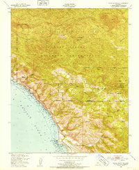
~ Burro Mountain CA topo map, 1:24000 scale, 7.5 X 7.5 Minute, Historical, 1949, updated 1953
Burro Mountain, California, USGS topographic map dated 1949.
Includes geographic coordinates (latitude and longitude). This topographic map is suitable for hiking, camping, and exploring, or framing it as a wall map.
Printed on-demand using high resolution imagery, on heavy weight and acid free paper, or alternatively on a variety of synthetic materials.
Topos available on paper, Waterproof, Poly, or Tyvek. Usually shipping rolled, unless combined with other folded maps in one order.
- Product Number: USGS-5509557
- Free digital map download (high-resolution, GeoPDF): Burro Mountain, California (file size: 18 MB)
- Map Size: please refer to the dimensions of the GeoPDF map above
- Weight (paper map): ca. 55 grams
- Map Type: POD USGS Topographic Map
- Map Series: HTMC
- Map Verison: Historical
- Cell ID: 6391
- Scan ID: 288695
- Imprint Year: 1953
- Woodland Tint: Yes
- Aerial Photo Year: 1947
- Field Check Year: 1949
- Datum: NAD27
- Map Projection: Polyconic
- Map published by United States Geological Survey
- Map published by United States Army Corps of Engineers
- Map published by United States Army
- Map Language: English
- Scanner Resolution: 600 dpi
- Map Cell Name: Burro Mountain
- Grid size: 7.5 X 7.5 Minute
- Date on map: 1949
- Map Scale: 1:24000
- Geographical region: California, United States
Neighboring Maps:
All neighboring USGS topo maps are available for sale online at a variety of scales.
Spatial coverage:
Topo map Burro Mountain, California, covers the geographical area associated the following places:
- Davis Canyon - Jones Mountain - Turkey Springs Campground - Lions Den Campground - Spruce Campground - Silver Peak - San Carpoforo Campground - Silver Peak Campground - Burro Mountain - Spruce Campground - Elk Campground - Estrella Campground - Three Peaks - Wagner Creek - Mount Mars - Salmon Cone - Three Peaks Campground - Dutra Place (historical) - School Spring - Lion Peak - Turkey Springs Campground - Dutra Flat Campground - Old Jones Ranch (historical) - W R Hearst Foremans Headquarters (historical) - Salmon Creek Ranger Station - Salmon Creek - Estrella Campground - Bald Top - Polar School (historical) - Lottie Potrero Campground - San Carpoforo Valley - Ragged Point - Salmon Head - Calizona Mine - Windy Point - Silver Creek Campground - Estrada Creek - Dutra Creek - Chris Flood Creek - Silver Peak Wilderness - Thorndyke Top - White Rock Number One - Little Burros Creek - Lions Den Campground - Ray Evans Ranch (historical) - Polar Star Mine - Dutra Flat Campground - San Carpoforo Creek
- Map Area ID: AREA35.87535.75-121.375-121.25
- Northwest corner Lat/Long code: USGSNW35.875-121.375
- Northeast corner Lat/Long code: USGSNE35.875-121.25
- Southwest corner Lat/Long code: USGSSW35.75-121.375
- Southeast corner Lat/Long code: USGSSE35.75-121.25
- Northern map edge Latitude: 35.875
- Southern map edge Latitude: 35.75
- Western map edge Longitude: -121.375
- Eastern map edge Longitude: -121.25


