
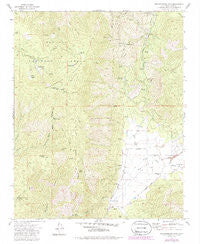
~ Breckenridge Mountain CA topo map, 1:24000 scale, 7.5 X 7.5 Minute, Historical, 1972, updated 1986
Breckenridge Mountain, California, USGS topographic map dated 1972.
Includes geographic coordinates (latitude and longitude). This topographic map is suitable for hiking, camping, and exploring, or framing it as a wall map.
Printed on-demand using high resolution imagery, on heavy weight and acid free paper, or alternatively on a variety of synthetic materials.
Topos available on paper, Waterproof, Poly, or Tyvek. Usually shipping rolled, unless combined with other folded maps in one order.
- Product Number: USGS-5509169
- Free digital map download (high-resolution, GeoPDF): Breckenridge Mountain, California (file size: 14 MB)
- Map Size: please refer to the dimensions of the GeoPDF map above
- Weight (paper map): ca. 55 grams
- Map Type: POD USGS Topographic Map
- Map Series: HTMC
- Map Verison: Historical
- Cell ID: 5332
- Scan ID: 300002
- Imprint Year: 1986
- Woodland Tint: Yes
- Photo Revision Year: 1985
- Aerial Photo Year: 1983
- Edit Year: 1985
- Field Check Year: 1972
- Datum: NAD27
- Map Projection: Lambert Conformal Conic
- Map published by United States Geological Survey
- Map Language: English
- Scanner Resolution: 600 dpi
- Map Cell Name: Breckenridge Mountain
- Grid size: 7.5 X 7.5 Minute
- Date on map: 1972
- Map Scale: 1:24000
- Geographical region: California, United States
Neighboring Maps:
All neighboring USGS topo maps are available for sale online at a variety of scales.
Spatial coverage:
Topo map Breckenridge Mountain, California, covers the geographical area associated the following places:
- Lazells Ranch - Breckenridge Meadows - KBAK-TV (Bakersfield) - Breckenridge - Bull Flat - Tungsten Chief Mill (historical) - Cherry Gap - Breckenridge Campground - Walker Basin - Breckenridge Meadows - Dutchman Prospect Spring - Shead Ranch - Weiss Canyon - Squirrel Meadow - Knox Ranch - Banada Ridge - Metoe Spring - Breckenridge Lodge - Julia Lake - Tungsten Chief Mine - Bear Trap Spring - Johnson Canyon - Lightner Ranch - Munzer Meadow - Agua Fria Spring - Flying S Ranch Airport - Johnson Spring - Home Spring - Walker Basin School (historical) - Williams Ranch - Shead Ranch - Hole in the Mountain - Breckenridge Mountain - Barrel Spring - Tungsten Chief Mill - Rankin Ranch - KERO-TV (Bakersfield) - Golf Meadow - Deer Springs - Breckenridge Mountain Lookout - Murphy Spring - Rancheria Creek - Flying Dutchman Creek - Johns Ranch - Breckenridge Fire Tower
- Map Area ID: AREA35.535.375-118.625-118.5
- Northwest corner Lat/Long code: USGSNW35.5-118.625
- Northeast corner Lat/Long code: USGSNE35.5-118.5
- Southwest corner Lat/Long code: USGSSW35.375-118.625
- Southeast corner Lat/Long code: USGSSE35.375-118.5
- Northern map edge Latitude: 35.5
- Southern map edge Latitude: 35.375
- Western map edge Longitude: -118.625
- Eastern map edge Longitude: -118.5


