
~ Big Pine Mtn CA topo map, 1:24000 scale, 7.5 X 7.5 Minute, Historical, 1964, updated 1965
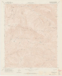
Big Pine Mtn, California, USGS topographic map dated 1964.
Includes geographic coordinates (latitude and longitude). This topographic map is suitable for hiking, camping, and exploring, or framing it as a wall map.
Printed on-demand using high resolution imagery, on heavy weight and acid free paper, or alternatively on a variety of synthetic materials.
Topos available on paper, Waterproof, Poly, or Tyvek. Usually shipping rolled, unless combined with other folded maps in one order.
- Product Number: USGS-5508541
- Free digital map download (high-resolution, GeoPDF): Big Pine Mtn, California (file size: 12 MB)
- Map Size: please refer to the dimensions of the GeoPDF map above
- Weight (paper map): ca. 55 grams
- Map Type: POD USGS Topographic Map
- Map Series: HTMC
- Map Verison: Historical
- Cell ID: 3795
- Scan ID: 302411
- Imprint Year: 1965
- Visual Version Number: 1
- Aerial Photo Year: 1958
- Field Check Year: 1964
- Datum: NAD27
- Map Projection: Polyconic
- Map published by United States Geological Survey
- Map Language: English
- Scanner Resolution: 600 dpi
- Map Cell Name: Big Pine Mountain
- Grid size: 7.5 X 7.5 Minute
- Date on map: 1964
- Map Scale: 1:24000
- Geographical region: California, United States
Neighboring Maps:
All neighboring USGS topo maps are available for sale online at a variety of scales.
Spatial coverage:
Topo map Big Pine Mtn, California, covers the geographical area associated the following places:
- Narrows Campground - Mission Pine Basin Campground - Jackrabbit Flat - Heath Campground - Judell Canyon - Alamar Guard Station - Mission Pine Trail - Lower Grapevine Campground - Grapevine Creek - Pelch Cabin (historical) - Bear Campground - Sisquoc Condor Sanctuary - Coche Campground - Mission Pine Basin - Big Pine Canyon - Bluff Camp Forest Service Faciltiy - Pens Campground - Poplar Campground - Upper Grapevine Campground - Bluff Campground - Samon Peak - Grapevine Trail - Fall Canyon - Chokecherry Spring - The Pines Campground - Lower Bear Campground - Logan Canyon - Pelch Camp - Big Pine Campground - Sisquoc Falls - Cottonwood Campground - Rattlesnake Canyon - Mansfield Campground - Big Pine Mountain
- Map Area ID: AREA34.7534.625-119.75-119.625
- Northwest corner Lat/Long code: USGSNW34.75-119.75
- Northeast corner Lat/Long code: USGSNE34.75-119.625
- Southwest corner Lat/Long code: USGSSW34.625-119.75
- Southeast corner Lat/Long code: USGSSE34.625-119.625
- Northern map edge Latitude: 34.75
- Southern map edge Latitude: 34.625
- Western map edge Longitude: -119.75
- Eastern map edge Longitude: -119.625


