
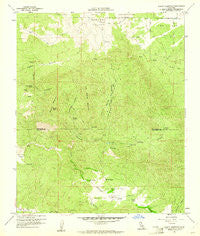
~ Beauty Mountain CA topo map, 1:24000 scale, 7.5 X 7.5 Minute, Historical, 1960, updated 1961
Beauty Mountain, California, USGS topographic map dated 1960.
Includes geographic coordinates (latitude and longitude). This topographic map is suitable for hiking, camping, and exploring, or framing it as a wall map.
Printed on-demand using high resolution imagery, on heavy weight and acid free paper, or alternatively on a variety of synthetic materials.
Topos available on paper, Waterproof, Poly, or Tyvek. Usually shipping rolled, unless combined with other folded maps in one order.
- Product Number: USGS-5508221
- Free digital map download (high-resolution, GeoPDF): Beauty Mountain, California (file size: 18 MB)
- Map Size: please refer to the dimensions of the GeoPDF map above
- Weight (paper map): ca. 55 grams
- Map Type: POD USGS Topographic Map
- Map Series: HTMC
- Map Verison: Historical
- Cell ID: 2911
- Scan ID: 288281
- Imprint Year: 1961
- Woodland Tint: Yes
- Aerial Photo Year: 1955
- Field Check Year: 1960
- Datum: NAD27
- Map Projection: Polyconic
- Map published by United States Geological Survey
- Map Language: English
- Scanner Resolution: 600 dpi
- Map Cell Name: Beauty Mountain
- Grid size: 7.5 X 7.5 Minute
- Date on map: 1960
- Map Scale: 1:24000
- Geographical region: California, United States
Neighboring Maps:
All neighboring USGS topo maps are available for sale online at a variety of scales.
Spatial coverage:
Topo map Beauty Mountain, California, covers the geographical area associated the following places:
- Beauty Peak - Pawnee Mine - Million Dollar Canyon - Talmadge Canyon - Talmadge Spring - Iron Spring Mountain - Chihuahua Valley - Beauty Mountain - Beauty Mountain Wilderness - Dick Spring - Million Dollar Spring - Rock Pile - Lone Pine Reservoir - Twin Lakes - Mitchell Camp - Iron Spring - Cooper Canyon - Iron Spring Canyon - Twin Lakes - Boden Field - Previtt Canyon - C R and H Trail - Cooper Cienega - Adobe Springs - Cooper Cienega Truck Trail
- Map Area ID: AREA33.533.375-116.75-116.625
- Northwest corner Lat/Long code: USGSNW33.5-116.75
- Northeast corner Lat/Long code: USGSNE33.5-116.625
- Southwest corner Lat/Long code: USGSSW33.375-116.75
- Southeast corner Lat/Long code: USGSSE33.375-116.625
- Northern map edge Latitude: 33.5
- Southern map edge Latitude: 33.375
- Western map edge Longitude: -116.75
- Eastern map edge Longitude: -116.625


