
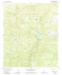
~ Barrett Lake CA topo map, 1:24000 scale, 7.5 X 7.5 Minute, Historical, 1960, updated 1984
Barrett Lake, California, USGS topographic map dated 1960.
Includes geographic coordinates (latitude and longitude). This topographic map is suitable for hiking, camping, and exploring, or framing it as a wall map.
Printed on-demand using high resolution imagery, on heavy weight and acid free paper, or alternatively on a variety of synthetic materials.
Topos available on paper, Waterproof, Poly, or Tyvek. Usually shipping rolled, unless combined with other folded maps in one order.
- Product Number: USGS-5508079
- Free digital map download (high-resolution, GeoPDF): Barrett Lake, California (file size: 15 MB)
- Map Size: please refer to the dimensions of the GeoPDF map above
- Weight (paper map): ca. 55 grams
- Map Type: POD USGS Topographic Map
- Map Series: HTMC
- Map Verison: Historical
- Cell ID: 2481
- Scan ID: 288219
- Imprint Year: 1984
- Woodland Tint: Yes
- Photo Revision Year: 1982
- Aerial Photo Year: 1980
- Edit Year: 1982
- Field Check Year: 1960
- Datum: NAD27
- Map Projection: Polyconic
- Map published by United States Geological Survey
- Map Language: English
- Scanner Resolution: 600 dpi
- Map Cell Name: Barrett Lake
- Grid size: 7.5 X 7.5 Minute
- Date on map: 1960
- Map Scale: 1:24000
- Geographical region: California, United States
Neighboring Maps:
All neighboring USGS topo maps are available for sale online at a variety of scales.
Spatial coverage:
Topo map Barrett Lake, California, covers the geographical area associated the following places:
- Reider Ranch Airport - Barrett Honor Camp - Barrett Lake - Dry Valley - McAlmond Canyon - Elena Mountain - Bee Valley - Mother Grundy Peak - San Diego City Conduit - Pine Valley Creek - Henry Junior Dam - Barber Mountain - Rattlesnake Canyon - Red Top - Barrett Dam - Japatu Station - Boneyard Canyon - Pats Canyon - Henry Jr 841 Dam - Wilson Creek - Deerhorn Valley - Bob Owens Canyon - Deerhorn Spring - White Mountain - Lawson Peak - Espinosa Creek - Eichenlaub Ranch - Gaskill Peak - Mary Jo Dam - Echo Mountain - Corral Canyon - Walker Ranch - Skunk Hollow - Hauser Canyon - Mary Jo 841-002 Dam - Horsethief Trailhead - Barrett Dam
- Map Area ID: AREA32.7532.625-116.75-116.625
- Northwest corner Lat/Long code: USGSNW32.75-116.75
- Northeast corner Lat/Long code: USGSNE32.75-116.625
- Southwest corner Lat/Long code: USGSSW32.625-116.75
- Southeast corner Lat/Long code: USGSSE32.625-116.625
- Northern map edge Latitude: 32.75
- Southern map edge Latitude: 32.625
- Western map edge Longitude: -116.75
- Eastern map edge Longitude: -116.625


