
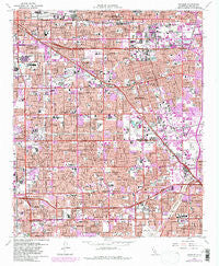
~ Anaheim CA topo map, 1:24000 scale, 7.5 X 7.5 Minute, Historical, 1965, updated 1981
Anaheim, California, USGS topographic map dated 1965.
Includes geographic coordinates (latitude and longitude). This topographic map is suitable for hiking, camping, and exploring, or framing it as a wall map.
Printed on-demand using high resolution imagery, on heavy weight and acid free paper, or alternatively on a variety of synthetic materials.
Topos available on paper, Waterproof, Poly, or Tyvek. Usually shipping rolled, unless combined with other folded maps in one order.
- Product Number: USGS-5507475
- Free digital map download (high-resolution, GeoPDF): Anaheim, California (file size: 20 MB)
- Map Size: please refer to the dimensions of the GeoPDF map above
- Weight (paper map): ca. 55 grams
- Map Type: POD USGS Topographic Map
- Map Series: HTMC
- Map Verison: Historical
- Cell ID: 922
- Scan ID: 287970
- Imprint Year: 1981
- Woodland Tint: Yes
- Photo Revision Year: 1981
- Aerial Photo Year: 1963
- Survey Year: 1965
- Datum: NAD27
- Map Projection: Polyconic
- Map published by United States Geological Survey
- Map Language: English
- Scanner Resolution: 600 dpi
- Map Cell Name: Anaheim
- Grid size: 7.5 X 7.5 Minute
- Date on map: 1965
- Map Scale: 1:24000
- Geographical region: California, United States
Neighboring Maps:
All neighboring USGS topo maps are available for sale online at a variety of scales.
Spatial coverage:
Topo map Anaheim, California, covers the geographical area associated the following places:
- Plantation Mobile Home Estates - Katella Mobile Home Estates - Sahara Mobile Home Park - Berrydale Trailer Park - South Anaheim - Bahia Trailer Villa - Prado Verde Mobile Home Park - Villa Capri Mobile Home Park - La Belle Fontane Estates - Cherokee Mobile Gardens - Ponderosa Mobile Home Estates - Sunkist Gardens - Miraflores (historical) - Oasis Mobile Home Park - Meadowlark Mobile Home Estates - Tree Mobile Home Park - Park Royale - La Jolla - Willowick Royal Mobile Home Park - Micaflores - Goldcrest Mobile Home Club - Stanton - Green Lantern Village - Summerset Mobile Home Estates - Ocean Breeze Trailer Park - Americana Mobile Home Park - West Anaheim - Santa Ysabel (historical) - Clair - Brookhurst - Parque Pacifico Mobile Home Park - Anaheim Mobile Home Estates - Del Ray Mobile Home Estates - Emerald Isle Mobile Home Park - Almond - Neff - Nutwood - Del Prado Mobile Park Club - West Grove Mobile Home Estates - Anaheim Shores - Golden Skies Mobile Home Park - Beach West Mobile Home Estates - Palm Lodge Mobile Home Estates - Orangetree - Garden Grove - West Anaheim Junction - Fernwood Mobile Home Park - Fuller Park - Rancho La Paz - Colonia Manzanilla - Anaheim Royal Mobile Home Park - Westminster Mobile Home Park - South Grove Mobile Home Estates - Casa Hermosa Mobile Home Park - Fullerton - Rancho Fullerton Mobile Home Estates - Anaheim - Eldorado Mobile Home Estates - Buena Park - Rancho Thirty-nine Mobile Home Park - Los Alamitos Junction
- Map Area ID: AREA33.87533.75-118-117.875
- Northwest corner Lat/Long code: USGSNW33.875-118
- Northeast corner Lat/Long code: USGSNE33.875-117.875
- Southwest corner Lat/Long code: USGSSW33.75-118
- Southeast corner Lat/Long code: USGSSE33.75-117.875
- Northern map edge Latitude: 33.875
- Southern map edge Latitude: 33.75
- Western map edge Longitude: -118
- Eastern map edge Longitude: -117.875


