
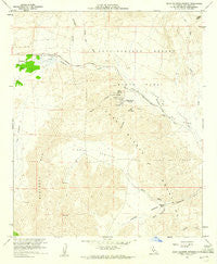
~ Agua Caliente Springs CA topo map, 1:24000 scale, 7.5 X 7.5 Minute, Historical, 1959, updated 1960
Agua Caliente Springs, California, USGS topographic map dated 1959.
Includes geographic coordinates (latitude and longitude). This topographic map is suitable for hiking, camping, and exploring, or framing it as a wall map.
Printed on-demand using high resolution imagery, on heavy weight and acid free paper, or alternatively on a variety of synthetic materials.
Topos available on paper, Waterproof, Poly, or Tyvek. Usually shipping rolled, unless combined with other folded maps in one order.
- Product Number: USGS-5507169
- Free digital map download (high-resolution, GeoPDF): Agua Caliente Springs, California (file size: 10 MB)
- Map Size: please refer to the dimensions of the GeoPDF map above
- Weight (paper map): ca. 55 grams
- Map Type: POD USGS Topographic Map
- Map Series: HTMC
- Map Verison: Historical
- Cell ID: 275
- Scan ID: 287825
- Imprint Year: 1960
- Woodland Tint: Yes
- Aerial Photo Year: 1955
- Field Check Year: 1959
- Datum: NAD27
- Map Projection: Polyconic
- Map published by United States Geological Survey
- Map Language: English
- Scanner Resolution: 600 dpi
- Map Cell Name: Agua Caliente Springs
- Grid size: 7.5 X 7.5 Minute
- Date on map: 1959
- Map Scale: 1:24000
- Geographical region: California, United States
Neighboring Maps:
All neighboring USGS topo maps are available for sale online at a variety of scales.
Spatial coverage:
Topo map Agua Caliente Springs, California, covers the geographical area associated the following places:
- Vallecito Stage Station County Park - Agua Caliente Springs - Agua Caliente Springs Airport - Smuggler Canyon - Vallecito Stage Station Cemetery - Sawtooth Mountains Wilderness - June Wash - Crawford Ranch - Burro Spring - Vallecito Valley - Moonlight Canyon - Bisnaga Alta Wash - Sawtooth Mountains - East Fork Ironwood Canyon - Inner Pasture - North Wash - Ironwood Canyon - Squaw Canyon - Ironwood Wash - Tierra Blanca Mountains - Red Top - East Fork Ironwood Wash - Agua Caliente County Park
- Map Area ID: AREA3332.875-116.375-116.25
- Northwest corner Lat/Long code: USGSNW33-116.375
- Northeast corner Lat/Long code: USGSNE33-116.25
- Southwest corner Lat/Long code: USGSSW32.875-116.375
- Southeast corner Lat/Long code: USGSSE32.875-116.25
- Northern map edge Latitude: 33
- Southern map edge Latitude: 32.875
- Western map edge Longitude: -116.375
- Eastern map edge Longitude: -116.25


