
~ Trona CA topo map, 1:250000 scale, 1 X 2 Degree, Historical, 1947, updated 1948
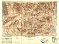
Trona, California, USGS topographic map dated 1947.
Includes geographic coordinates (latitude and longitude). This topographic map is suitable for hiking, camping, and exploring, or framing it as a wall map.
Printed on-demand using high resolution imagery, on heavy weight and acid free paper, or alternatively on a variety of synthetic materials.
Topos available on paper, Waterproof, Poly, or Tyvek. Usually shipping rolled, unless combined with other folded maps in one order.
- Product Number: USGS-5506757
- Free digital map download (high-resolution, GeoPDF): Trona, California (file size: 18 MB)
- Map Size: please refer to the dimensions of the GeoPDF map above
- Weight (paper map): ca. 55 grams
- Map Type: POD USGS Topographic Map
- Map Series: HTMC
- Map Verison: Historical
- Cell ID: 74973
- Scan ID: 302169
- Imprint Year: 1948
- Aerial Photo Year: 1947
- Datum: NAD27
- Map Projection: Transverse Mercator
- Shaded Relief map: Yes
- Map published by United States Army Corps of Engineers
- Map published by United States Army
- Map Language: English
- Scanner Resolution: 600 dpi
- Map Cell Name: Trona
- Grid size: 1 X 2 Degree
- Date on map: 1947
- Map Scale: 1:250000
- Geographical region: California, United States
Neighboring Maps:
All neighboring USGS topo maps are available for sale online at a variety of scales.
Spatial coverage:
Topo map Trona, California, covers the geographical area associated the following places:
- Cronese Valley - Goldstone - Balch - Saint Elmo (historical) - Westend - Saltdale - Teagle (historical) - China Lake Acres - North Edwards - Basin - Ashford Mill (historical) - Cronise (historical) - Indian Wells - Randsburg - Rand - Baxter (historical) - Mars - Baker - Venus - Linnie - Ridgecrest - Zzyzx - Trona - Sperry - Brown - Fremont - Apollo - Valley Wells - Garlock - Belfast (historical) - Johannesburg - Gypsite - Ceneda - Armistead - Cantil - Fort Irwin - Skytop - Midway - Pearsonville - Copper City - Lakeview Mobile Home Park - Little Lake - Baker - Old Garlock - Spangler - South Trona - Desert Lake - Shoshone - West Baker (historical) - Dumont (historical) - Dunn - Borosolvay - China Lake - New Dunn - Echo - Mojave Base - Rancho Seco - Terese (historical) - Goler Heights - Ricardo - Inyokern - King (historical) - Valjean - Coso - Tecopa - Redrock (historical) - Argus - Atolia - Red Mountain - North Muroc (historical) - Crucero - Talc (historical) - Leliter (historical) - Bradys - Beacon Station - Searles Valley - California City - Pioneer Point - Aerial Acres - Renoville - Searles - Lockhart - Harts Place - Ashford Junction - Afton - Acme (historical)
- Map Area ID: AREA3635-118-116
- Northwest corner Lat/Long code: USGSNW36-118
- Northeast corner Lat/Long code: USGSNE36-116
- Southwest corner Lat/Long code: USGSSW35-118
- Southeast corner Lat/Long code: USGSSE35-116
- Northern map edge Latitude: 36
- Southern map edge Latitude: 35
- Western map edge Longitude: -118
- Eastern map edge Longitude: -116


