
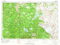
~ Susanville CA topo map, 1:250000 scale, 1 X 2 Degree, Historical, 1962, updated 1965
Susanville, California, USGS topographic map dated 1962.
Includes geographic coordinates (latitude and longitude). This topographic map is suitable for hiking, camping, and exploring, or framing it as a wall map.
Printed on-demand using high resolution imagery, on heavy weight and acid free paper, or alternatively on a variety of synthetic materials.
Topos available on paper, Waterproof, Poly, or Tyvek. Usually shipping rolled, unless combined with other folded maps in one order.
- Product Number: USGS-5506755
- Free digital map download (high-resolution, GeoPDF): Susanville, California (file size: 19 MB)
- Map Size: please refer to the dimensions of the GeoPDF map above
- Weight (paper map): ca. 55 grams
- Map Type: POD USGS Topographic Map
- Map Series: HTMC
- Map Verison: Historical
- Cell ID: 75007
- Scan ID: 302168
- Imprint Year: 1965
- Woodland Tint: Yes
- Field Check Year: 1962
- Datum: NAD27
- Map Projection: Universal Transverse Mercator
- Map published by United States Geological Survey
- Map Language: English
- Scanner Resolution: 600 dpi
- Map Cell Name: Susanville
- Grid size: 1 X 2 Degree
- Date on map: 1962
- Map Scale: 1:250000
- Geographical region: California, United States
Neighboring Maps:
All neighboring USGS topo maps are available for sale online at a variety of scales.
Spatial coverage:
Topo map Susanville, California, covers the geographical area associated the following places:
- Crescent Mills - Brockman - Goumaz (historical) - Four Corners - Herlong - Edgemont (historical) - Jonesville - Favinger Place - Cassel - Dixie - Midway - Ravendale - Viola - Termo - Robbers Creek - Susanville - Sheepshead - Halls Flat - Peninsula Village - Thompson Place - Foxwood - Saint Bernard - Polk Springs - Canyondam - Lake Almanor Country Club - Campbellville - Hot Springs - Marian Place - Milford - Redwoods - Hillcrest - Buntingville - Shumway - Almanor - Wells Place - Belfast - Genesee - Caribou - Prattville - Finley Place - Four Corners - Hat Creek - McClure Place - Shingletown - Peligreen Place - Westwood Junction - Wengler - Lake Almanor West - Coppervale - Paxton - Haven - Horse Lake - Crest - Burney - Manton - Spalding Tract - Payne Place - Pape Place - McKenzie Place - Chester - Glenburn - Fern - Lomo - The Crossing - Moran - Lake Almanor Peninsula - Beal Place - Facht Place - Buena Vista - East Shore - Little Valley - Old Station - Standish - Lyonsville - Viewland - Greenville - Calneva - Herlong Junction - Manzanita Lake - Virgilia - Jellico - Keddie - Eastman Place - Stacy - Wendel - Whitmore - Paynes Creek - Belden - Mineral - Westwood - Morgan Springs - Doyles Corner - Leavitt - Johnson Park - Janesville - Round Valley (historical) - Norvell - Meyers Place - Round Mountain - Tenmile (historical)
- Map Area ID: AREA4140-122-120
- Northwest corner Lat/Long code: USGSNW41-122
- Northeast corner Lat/Long code: USGSNE41-120
- Southwest corner Lat/Long code: USGSSW40-122
- Southeast corner Lat/Long code: USGSSE40-120
- Northern map edge Latitude: 41
- Southern map edge Latitude: 40
- Western map edge Longitude: -122
- Eastern map edge Longitude: -120


