
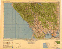
~ Santa Rosa CA topo map, 1:250000 scale, 1 X 2 Degree, Historical, 1949, updated 1949
Santa Rosa, California, USGS topographic map dated 1949.
Includes geographic coordinates (latitude and longitude). This topographic map is suitable for hiking, camping, and exploring, or framing it as a wall map.
Printed on-demand using high resolution imagery, on heavy weight and acid free paper, or alternatively on a variety of synthetic materials.
Topos available on paper, Waterproof, Poly, or Tyvek. Usually shipping rolled, unless combined with other folded maps in one order.
- Product Number: USGS-5506751
- Free digital map download (high-resolution, GeoPDF): Santa Rosa, California (file size: 20 MB)
- Map Size: please refer to the dimensions of the GeoPDF map above
- Weight (paper map): ca. 55 grams
- Map Type: POD USGS Topographic Map
- Map Series: HTMC
- Map Verison: Historical
- Cell ID: 74995
- Scan ID: 707596
- Imprint Year: 1949
- Woodland Tint: Yes
- Aerial Photo Year: 1944
- Datum: NAD27
- Map Projection: Transverse Mercator
- Shaded Relief map: Yes
- Map published by United States Army Corps of Engineers
- Map published by United States Army
- Map Language: English
- Scanner Resolution: 508 dpi
- Map Cell Name: Santa Rosa
- Grid size: 1 X 2 Degree
- Date on map: 1949
- Map Scale: 1:250000
- Geographical region: California, United States
Neighboring Maps:
All neighboring USGS topo maps are available for sale online at a variety of scales.
Spatial coverage:
Topo map Santa Rosa, California, covers the geographical area associated the following places:
- Forest Lake - Fulton - East Windsor - Gualala - Howell Mountain - Hobergs - Walter Springs - Santa Nella - Nitro - Summerhome Park - Haystack - Goat Rock - Point Arena - Glenview - Forbes (historical) - Thoman - Asti - Monticello (historical) - Sobrante - Larkfield - Molino - Sleepy Hollow - Rocktram - Graton - Mococo - Middletown - Washoe - Highland Springs - Subeet - Kelseyville - Martinez - Yorkville - Sousa Corners - Agua Caliente - Guenoc (historical) - Twin Lakes - Omus - Creston - Stronetta - Marconi - Dorr Place - Berryessa Highlands - McNear - Wildwood (historical) - Rancho Ramon Mobile Home Park - San Geronimo - Collins - Spanish Flat Resort - Waldrue Heights - Edendale - Lucas Valley - Stony Point - Whispering Pines - Redbud Park (historical) - Caldwell Pines - Las Lomas - Terra Linda - Little Penny - Glenbrook - Clearlake Park - Anchor Bay - Rumsey - Lawndale - Crittendon (historical) - Clear Lake Riviera - Felice (historical) - Port Chicago (historical) - Dawes - Old Red Rock Place - Greenwood (historical) - Bivalve - Rolands - De Anza Moon Valley Mobile Home Park - Clima - Tolenas - Ratto Landing - Seahaven - Green Valley - Chabot Terrace - Harrington - Ross - Alliance Redwood - Mark West Springs - Squab - Suval - Bayview - Larkmead - Grant - Geyserville - Bahia - Ocean Roar - Liberty - Fredericks - Park Creek Village Mobile Home Park - Salvador - Old Ornbaun Hot Springs - Northwood Heights - Nervo - Melita - Sonoma Vista
- Map Area ID: AREA3938-124-122
- Northwest corner Lat/Long code: USGSNW39-124
- Northeast corner Lat/Long code: USGSNE39-122
- Southwest corner Lat/Long code: USGSSW38-124
- Southeast corner Lat/Long code: USGSSE38-122
- Northern map edge Latitude: 39
- Southern map edge Latitude: 38
- Western map edge Longitude: -124
- Eastern map edge Longitude: -122


