
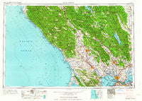
~ Santa Rosa CA topo map, 1:250000 scale, 1 X 2 Degree, Historical, 1964, updated 1964
Santa Rosa, California, USGS topographic map dated 1964.
Includes geographic coordinates (latitude and longitude). This topographic map is suitable for hiking, camping, and exploring, or framing it as a wall map.
Printed on-demand using high resolution imagery, on heavy weight and acid free paper, or alternatively on a variety of synthetic materials.
Topos available on paper, Waterproof, Poly, or Tyvek. Usually shipping rolled, unless combined with other folded maps in one order.
- Product Number: USGS-5506743
- Free digital map download (high-resolution, GeoPDF): Santa Rosa, California (file size: 20 MB)
- Map Size: please refer to the dimensions of the GeoPDF map above
- Weight (paper map): ca. 55 grams
- Map Type: POD USGS Topographic Map
- Map Series: HTMC
- Map Verison: Historical
- Cell ID: 74995
- Scan ID: 302155
- Imprint Year: 1964
- Woodland Tint: Yes
- Field Check Year: 1958
- Datum: Unstated
- Map Projection: Transverse Mercator
- Map published by United States Army Corps of Engineers
- Map published by United States Army
- Map Language: English
- Scanner Resolution: 600 dpi
- Map Cell Name: Santa Rosa
- Grid size: 1 X 2 Degree
- Date on map: 1964
- Map Scale: 1:250000
- Geographical region: California, United States
Neighboring Maps:
All neighboring USGS topo maps are available for sale online at a variety of scales.
Spatial coverage:
Topo map Santa Rosa, California, covers the geographical area associated the following places:
- Haystack - Collins - Salmon Creek - Graton - Sousa Corners - Alderglen Springs - South Vallejo - Pieta - Lombard - Vineyard Valley Mobile Home Park - Napa Abajo - Forestville - Jimtown - Eldridge - Caymus (historical) - The Oaks - Oleum - Bloomfield - Thomasson - El Bonita - Union - Big Bend - Rockville - Noel Heights - Twin Lakes - Cotati - Edendale - Carquinez Heights - Castle Rock Springs - Napa Junction - Hopyard (historical) - Stewarts Point - Creston - Port Chicago (historical) - Buchli - Northwood Heights - Eckley - San Antonio - Summerhome Park - Clearlake Highlands - Yorkville - Los Guilicos - Hardin (historical) - Sears Point - Ross - Harry Floyd Terrace - Atlas - Cypress Grove - Larkmead - Monte Rio - Guenoc (historical) - Luzon - Bonilla - Flosden (historical) - Blakes Landing - Seahaven - Mountain View - Sonoma - Marconi - Rancho Vista Mobile Home Park - Pine Grove - Mills - Pinole - Carmet - Russell - Embarcadero - Barro - Hercules - Las Gallinas - Chianti - Tocaloma - Omus - Irving (historical) - Stronetta - South Santa Rosa - Selby - Flumeville - Bayview - Guerneville - Dorr Place - Ely (historical) - Montesano - Golf (historical) - Redbud Park (historical) - Spanish Flat Resort - Oak Knoll - Hobergs - Guernewood - Black Oaks - Bridgehaven - De Anza Moon Valley Mobile Home Park - Two Rock - Carneros (historical) - Saint Vincent - Point Reyes (historical) - Diamond A Ranch Estates - Oakville - Rankin (historical) - Cuttings Wharf - Middleton
- Map Area ID: AREA3938-124-122
- Northwest corner Lat/Long code: USGSNW39-124
- Northeast corner Lat/Long code: USGSNE39-122
- Southwest corner Lat/Long code: USGSSW38-124
- Southeast corner Lat/Long code: USGSSE38-122
- Northern map edge Latitude: 39
- Southern map edge Latitude: 38
- Western map edge Longitude: -124
- Eastern map edge Longitude: -122


