
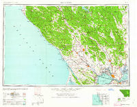
~ Santa Rosa CA topo map, 1:250000 scale, 1 X 2 Degree, Historical, 1962
Santa Rosa, California, USGS topographic map dated 1962.
Includes geographic coordinates (latitude and longitude). This topographic map is suitable for hiking, camping, and exploring, or framing it as a wall map.
Printed on-demand using high resolution imagery, on heavy weight and acid free paper, or alternatively on a variety of synthetic materials.
Topos available on paper, Waterproof, Poly, or Tyvek. Usually shipping rolled, unless combined with other folded maps in one order.
- Product Number: USGS-5506741
- Free digital map download (high-resolution, GeoPDF): Santa Rosa, California (file size: 15 MB)
- Map Size: please refer to the dimensions of the GeoPDF map above
- Weight (paper map): ca. 55 grams
- Map Type: POD USGS Topographic Map
- Map Series: HTMC
- Map Verison: Historical
- Cell ID: 74995
- Scan ID: 302154
- Woodland Tint: Yes
- Datum: Unstated
- Map Projection: Transverse Mercator
- Map published by United States Army Corps of Engineers
- Map published by United States Army
- Map Language: English
- Scanner Resolution: 600 dpi
- Map Cell Name: Santa Rosa
- Grid size: 1 X 2 Degree
- Date on map: 1962
- Map Scale: 1:250000
- Geographical region: California, United States
Neighboring Maps:
All neighboring USGS topo maps are available for sale online at a variety of scales.
Spatial coverage:
Topo map Santa Rosa, California, covers the geographical area associated the following places:
- Turner - Marinwood - Pueblo Serena Mobile Home Park - Hobergs - Creston - Vallejo - Bonilla - Rockville - Veteran Heights - Embarcadero - Four Corners - East Windsor - Northwood Heights - Point Reyes (historical) - Country Villa Estates - Cloverdale - Spanish Flat Resort - Maltby - Guinda - Jacksnipe - Brooks - Taylorville (historical) - Duncans Mills - Makahmo (historical) - Larkmead - Selby - Salmon Creek - Flosden (historical) - Camp Thayer - Oasis - Guenoc (historical) - Valley Ford - Sacramento Landing - Valley Crossing - Caymus (historical) - Ohmer (historical) - Salvador - Temelec - Madrone (historical) - Christie - Signal Port (historical) - Fairville - Calistoga - Corona (historical) - Middletown - Fairfield - Rutherford - Marconi - Nicks Cove - Hale Place - Riccas Corner - Walsh Landing - Union - Vincent Landing - Pine Grove - Flosden Acres - Guadalcanal Village - Glenview - Little Penny - Edendale - Oakmont - Rocktram - McDonald - Vineyard Valley Mobile Home Park - Atlas - Oak Knoll - Cadenasso - Rio Dell - Freestone - Shipyard Acres - Stronetta - Clima - Middleton - Irving (historical) - Mills - Cordelia - Harbin Springs - Geyserville - Five Brooks - Harbin Springs Annex - Suisun - Sheridan - Brazos - Seigler Springs - Ely (historical) - Golf (historical) - Guernewood Park - Millerton - Boyes Hot Springs - Thoman - Angwin - Adams - Walter Springs - Healdsburg - Port Chicago (historical) - Simi - Monticello (historical) - Crittendon (historical) - Saint Vincent - Tormey
- Map Area ID: AREA3938-124-122
- Northwest corner Lat/Long code: USGSNW39-124
- Northeast corner Lat/Long code: USGSNE39-122
- Southwest corner Lat/Long code: USGSSW38-124
- Southeast corner Lat/Long code: USGSSE38-122
- Northern map edge Latitude: 39
- Southern map edge Latitude: 38
- Western map edge Longitude: -124
- Eastern map edge Longitude: -122


