
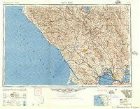
~ Santa Rosa CA topo map, 1:250000 scale, 1 X 2 Degree, Historical, 1947
Santa Rosa, California, USGS topographic map dated 1947.
Includes geographic coordinates (latitude and longitude). This topographic map is suitable for hiking, camping, and exploring, or framing it as a wall map.
Printed on-demand using high resolution imagery, on heavy weight and acid free paper, or alternatively on a variety of synthetic materials.
Topos available on paper, Waterproof, Poly, or Tyvek. Usually shipping rolled, unless combined with other folded maps in one order.
- Product Number: USGS-5506739
- Free digital map download (high-resolution, GeoPDF): Santa Rosa, California (file size: 30 MB)
- Map Size: please refer to the dimensions of the GeoPDF map above
- Weight (paper map): ca. 55 grams
- Map Type: POD USGS Topographic Map
- Map Series: HTMC
- Map Verison: Historical
- Cell ID: 74995
- Scan ID: 302153
- Aerial Photo Year: 1944
- Datum: NAD27
- Map Projection: Transverse Mercator
- Shaded Relief map: Yes
- Map published by United States Army Corps of Engineers
- Map published by United States Army
- Map Language: English
- Scanner Resolution: 600 dpi
- Map Cell Name: Santa Rosa
- Grid size: 1 X 2 Degree
- Date on map: 1947
- Map Scale: 1:250000
- Geographical region: California, United States
Neighboring Maps:
All neighboring USGS topo maps are available for sale online at a variety of scales.
Spatial coverage:
Topo map Santa Rosa, California, covers the geographical area associated the following places:
- Orchard - Little Penny - Los Guilicos - Vineyard Valley Mobile Home Park - Goat Rock - Simi - Redbud Park (historical) - Spanish Flat Resort - Two Rock - Barro - Valley Crossing - Yountville - Duncan Springs - Rose (historical) - Leisure Lake Mobile Home Park - Sears Point - Pope Valley - Cobb - Temelec - Old Red Rock Place - Vichy Springs - Liberty - Blakes Landing - Glencove - Alderglen Springs - Woodleaf - Manzana - Marshall - Annapolis - Collins - Cypress Grove - Lakeville - Four Corners - Jewell - Loch Lomond - Burdell - Williams (historical) - Guenoc (historical) - Sea Ranch - Corona (historical) - Mailliard (historical) - Inverness - Esparto - Sunrise Vista - Danielson - Krug - Boyes Hot Springs - Riccas Corner - Northwood Lodge - Fredericks - Capay - Nervo - Napa Junction - Bayo Vista - Turner - Napa - Wildwood (historical) - Maltby - Mirabel (historical) - Kenwood - Squab - Mirabel Park - Subeet - San Geronimo - Washoe - Twin Lakes - Crockett - Oasis - Bailhache - Schellville - Sonoma - Highcroft - Carquinez Heights - Russell - Ettawa Springs - Pueblo Serena Mobile Home Park - Hurlbut - Salmon Creek - Sobrante - Chadbourne - Odd Fellows Park - Vineburg - Pine Grove - Millerton - Seigler Springs - Nacomis Indian Rancheria - Hopland - Vine Hill - Fetters Hot Springs - Black Oaks - Mercuryville - Trenton - Sulphur Springs (historical) - Dillon Beach - Hopyard (historical) - Deer Park - Carmet - Madrone (historical) - Zinfandel - Yorkville
- Map Area ID: AREA3938-124-122
- Northwest corner Lat/Long code: USGSNW39-124
- Northeast corner Lat/Long code: USGSNE39-122
- Southwest corner Lat/Long code: USGSSW38-124
- Southeast corner Lat/Long code: USGSSE38-122
- Northern map edge Latitude: 39
- Southern map edge Latitude: 38
- Western map edge Longitude: -124
- Eastern map edge Longitude: -122


