
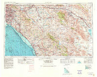
~ Santa Ana CA topo map, 1:250000 scale, 1 X 2 Degree, Historical, 1959, updated 1980
Santa Ana, California, USGS topographic map dated 1959.
Includes geographic coordinates (latitude and longitude). This topographic map is suitable for hiking, camping, and exploring, or framing it as a wall map.
Printed on-demand using high resolution imagery, on heavy weight and acid free paper, or alternatively on a variety of synthetic materials.
Topos available on paper, Waterproof, Poly, or Tyvek. Usually shipping rolled, unless combined with other folded maps in one order.
- Product Number: USGS-5506723
- Free digital map download (high-resolution, GeoPDF): Santa Ana, California (file size: 19 MB)
- Map Size: please refer to the dimensions of the GeoPDF map above
- Weight (paper map): ca. 55 grams
- Map Type: POD USGS Topographic Map
- Map Series: HTMC
- Map Verison: Historical
- Cell ID: 69016
- Scan ID: 707588
- Imprint Year: 1980
- Woodland Tint: Yes
- Aerial Photo Year: 1976
- Edit Year: 1979
- Datum: NAD27
- Map Projection: Transverse Mercator
- Map published by United States Geological Survey
- Map Language: English
- Scanner Resolution: 508 dpi
- Map Cell Name: Santa Ana
- Grid size: 1 X 2 Degree
- Date on map: 1959
- Map Scale: 1:250000
- Geographical region: California, United States
Neighboring Maps:
All neighboring USGS topo maps are available for sale online at a variety of scales.
Spatial coverage:
Topo map Santa Ana, California, covers the geographical area associated the following places:
- Biskra Palms - Rancho Carlsbad Trailer Park - Bali-Hi Mobile Home Lodge - Homeland - Pushawalla Palms - Rowland Heights - Riverside Junction - Santa Ana Gardens - Riverside - South Oceanside - Laguna Woods - Pauma Valley - El Cerrito - Home Gardens - Talich - Riviera Mobile Home Park - Salton Sea Beach - Moreno Knolls - Cherry Valley - El Toro Mobile Home Estates - Coach Royal Trailer Park - Eden Hot Springs - California Mobile Home Park - Brea - Rancho Fullerton Mobile Home Estates - South Grove Mobile Home Estates - Esperanza - Don (historical) - Fern Valley - La Bolsa - Rancho La Paz - East La Mirada - Lake Crest Estates - Wanda (historical) - DeLuz - South Laguna - Fountain Valley Mobile Home Estates - Casa Grande Estates Mobile Home Park - Ellis - LaMoree Mobile Estates - Banning - Palm Springs - Bonsall - Tiki Mobile Village - Holcomb Village - Desert Hills Trailer Park - Morettis Junction - Anaheim Royal Mobile Home Park - Valle de los Caballos - Sycamore Springs - La Paloma - Greenleaf Mobile Home Park - Rail-A-Way Trailer Park - Bay Shores - Rancho Trabuco - De Anza Village - Desert Edge - Oasis Mobile Home Park - Santa Margarita Groves - Fuller Park - Chino Hills - Sahara Mobile Home Park - Sunny Hills - Sedco Hills - Oceanside - Rancho del Avion Capistrano Mobile Home Park - Olinda (historical) - Ramona Bowl - Paularino - Terra Cotta - Porphyry - Plantation Mobile Home Estates - Hacienda Mobile Home Park - Corona del Mar - Ysidora (historical) - Saddleback Mobile Lodge - Arlanza - San Juan Mobile Home Estates - Ocotillo Wells - Lido Isle - Sunset Terrace Mobile Home Park - Desert Lodge - Escondido Terrace Mobile Home Park - Ribbonwood - Cahuilla - East Hemet - Carlsbad - Colonia Manzanilla - Mission Viejo - Aliso - The Views Mobile Home Park - Garnet - West Anaheim - Pedley - Browning - Escondido - Jofegan - Lilac - Lakeview - Cerro Villa Heights
- Map Area ID: AREA3433-118-116
- Northwest corner Lat/Long code: USGSNW34-118
- Northeast corner Lat/Long code: USGSNE34-116
- Southwest corner Lat/Long code: USGSSW33-118
- Southeast corner Lat/Long code: USGSSE33-116
- Northern map edge Latitude: 34
- Southern map edge Latitude: 33
- Western map edge Longitude: -118
- Eastern map edge Longitude: -116


