
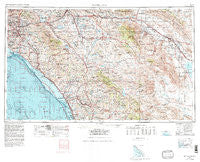
~ Santa Ana CA topo map, 1:250000 scale, 1 X 2 Degree, Historical, 1959, updated 1980
Santa Ana, California, USGS topographic map dated 1959.
Includes geographic coordinates (latitude and longitude). This topographic map is suitable for hiking, camping, and exploring, or framing it as a wall map.
Printed on-demand using high resolution imagery, on heavy weight and acid free paper, or alternatively on a variety of synthetic materials.
Topos available on paper, Waterproof, Poly, or Tyvek. Usually shipping rolled, unless combined with other folded maps in one order.
- Product Number: USGS-5506721
- Free digital map download (high-resolution, GeoPDF): Santa Ana, California (file size: 26 MB)
- Map Size: please refer to the dimensions of the GeoPDF map above
- Weight (paper map): ca. 55 grams
- Map Type: POD USGS Topographic Map
- Map Series: HTMC
- Map Verison: Historical
- Cell ID: 69016
- Scan ID: 302142
- Imprint Year: 1980
- Woodland Tint: Yes
- Visual Version Number: 1
- Aerial Photo Year: 1976
- Edit Year: 1979
- Field Check Year: 1959
- Datum: NAD27
- Map Projection: Transverse Mercator
- Map published by United States Geological Survey
- Map published by United States Department of Commerce
- Map Language: English
- Scanner Resolution: 600 dpi
- Map Cell Name: Santa Ana
- Grid size: 1 X 2 Degree
- Date on map: 1959
- Map Scale: 1:250000
- Geographical region: California, United States
Neighboring Maps:
All neighboring USGS topo maps are available for sale online at a variety of scales.
Spatial coverage:
Topo map Santa Ana, California, covers the geographical area associated the following places:
- Harbor Mobile Home Park - Town and Country Mobile Home Park - Rancho Trabuco - El Morro Beach Trailer Park (historical) - Sea Aire Mobile Home Park - Desert Shores - Harrison Park - Gavilan Hills - Arcilla - Rowland Heights - Silverado - Yorba - Prenda - Hacienda Heights - Silver Spur Mobile Manor - Rincon - Vista Verde Estates Mobile Home Park - Mira Loma - Weisel - Wildomar - Ellis - Parque Pacifico Mobile Home Park - Sky Valley Mobile Home Park - Mountain View Mobile Estates - Ocean Hills - Caleb (historical) - Bellview Park Mobile Home Park - Sleepy Hollow - Vista Santa Rosa - Coachella - South Grove Mobile Home Estates - Valley Center - LaMoree Mobile Estates - Emerald Isle Mobile Home Park - Ramona - Orange Mobile Home Park - Golden Skies Mobile Home Park - Sahara Mobile Home Park - Temecula - One Hundred Palms - La Costa - Thermal - Banner - Taggin Wagon Mobile Home Park - Los Tules - Cowan Heights - Laguna Beach - Del Ray Mobile Home Estates - Sundance Mobile Home Park - Sunny Hills - San Luis Rey - Prado Verde Mobile Home Park - El Modena - South Santa Ana - Summerset Mobile Home Estates - Rio Vista Mobile Home Estates - Ocotillo Wells - Palm Springs - Sylvan Meadows - Villa Capri Mobile Home Park - DeLuz - Bolsa Verde - Beachwood Trailer Park - Beach West Mobile Home Estates - Green Valley Mobile Estates - El Toro Mobile Home Estates - East Irvine - Bolsa - Greenleaf Mobile Home Park - Rancho La Siesta Mobile Home Park - Las Flores - Newport Beach - Oak Grove - Sunkist Gardens - Oasis Mobile Home Park - Valerie - Escondido Terrace Mobile Home Park - Julian - Laguna Hills - Moreno Valley - North Elsinore - Rubidoux - Cahuilla Hills - Rainbow - Placentia - Emerald Bay - Stoneridge Mobile Home Park - Beeks Place - Carefree Ranch Mobile Home Park - La Habra - Fountain Valley - Brea - Newport Coast - Winterwarm - West Anaheim - Friendly Hills Manor Mobile Home Park - Cathedral City - Westminster Mobile Home Park - Del Cerro Mobile Home Estates - Indian Wells
- Map Area ID: AREA3433-118-116
- Northwest corner Lat/Long code: USGSNW34-118
- Northeast corner Lat/Long code: USGSNE34-116
- Southwest corner Lat/Long code: USGSSW33-118
- Southeast corner Lat/Long code: USGSSE33-116
- Northern map edge Latitude: 34
- Southern map edge Latitude: 33
- Western map edge Longitude: -118
- Eastern map edge Longitude: -116


