
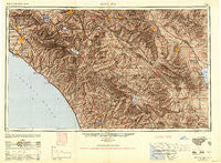
~ Santa Ana CA topo map, 1:250000 scale, 1 X 2 Degree, Historical, 1949, updated 1949
Santa Ana, California, USGS topographic map dated 1949.
Includes geographic coordinates (latitude and longitude). This topographic map is suitable for hiking, camping, and exploring, or framing it as a wall map.
Printed on-demand using high resolution imagery, on heavy weight and acid free paper, or alternatively on a variety of synthetic materials.
Topos available on paper, Waterproof, Poly, or Tyvek. Usually shipping rolled, unless combined with other folded maps in one order.
- Product Number: USGS-5506711
- Free digital map download (high-resolution, GeoPDF): Santa Ana, California (file size: 20 MB)
- Map Size: please refer to the dimensions of the GeoPDF map above
- Weight (paper map): ca. 55 grams
- Map Type: POD USGS Topographic Map
- Map Series: HTMC
- Map Verison: Historical
- Cell ID: 69016
- Scan ID: 302137
- Imprint Year: 1949
- Aerial Photo Year: 1944
- Datum: NAD27
- Map Projection: Transverse Mercator
- Shaded Relief map: Yes
- Map published by United States Army
- Map Language: English
- Scanner Resolution: 600 dpi
- Map Cell Name: Santa Ana
- Grid size: 1 X 2 Degree
- Date on map: 1949
- Map Scale: 1:250000
- Geographical region: California, United States
Neighboring Maps:
All neighboring USGS topo maps are available for sale online at a variety of scales.
Spatial coverage:
Topo map Santa Ana, California, covers the geographical area associated the following places:
- Carriage Mobile Home Estates - Leucadia - El Rancho Mobile Home Park - Anaheim Royal Mobile Home Park - Los Alamitos Junction - Desert Edge - Leffingwell - Hidden Palms - Silverado - Palm Desert Country - Midway City - Play Port Mobile Home Village - Caravana Trailer Lodge - Vista Verde Estates Mobile Home Park - Prothero Mobile Home Park - Rancho las Perris - Laguna Vista Trailer Park - Park Encinitas Trailer Park - Borrego - Costa Mesa - Pine Cove - Wanda (historical) - Huntington Shorecliffs Mobile Home Park - Galivan - Regal Mobile Club Estates - Bermuda Dunes - Edom - Riviera Mobile Home Park - Colina Vista - Serrano Place - Peralta Hills - Warm Springs Mobile Home Park - Vista Cascade Mobile Home Park - De Luz Heights - Thermal - Liberty Mobile Home Court - Green Valley Mobile Home Park - May - Rimlon - Dos Palmas Corners - South Grove Mobile Home Estates - Lemona - Laguna Niguel - Casa Loma - Mission Hills Mobile Home Park - Canyon Lake - Prado Verde Mobile Home Park - Temecula - Modjeska - Esperanza - Alessandro - Rowland Heights - Talbert - Brea Chem - Sunnyside Estates - Bali-Hi Mobile Home Lodge - Banning - Box Springs - Foothill Ranch - Como - Salvia - Orange Park Acres - Rancho Thirty-nine Mobile Home Park - Santa Ysabel - Ysidora (historical) - Serrano Heights - Vista Manor Trailer Park - Ellis - Lilac - Seacliffe Mobile Home Park - Glenoaks Country - Jofegan - Rancho Santa Fe - Julian - De Anza Village - Indian Wells - Newport Coast - Driftwood Mobile Home Park - San Felipe - Anaheim Hills - Hidden Meadows - Carbondale (historical) - Rancho Alipaz Mobile Home Park - Corona - North Tustin - La Costa - Yorba - Rancho Huntington Mobile Home Park - Del Prado Mobile Park Club - Hoosier Trailer Court - Santa Ana - Green Tree Estates Mobile Home Park - Oak Haven Estates - The Gables - Sycamore Hills - Goldcrest Mobile Home Club - Pinyon Pines - Taylor - Cowan Heights - South Oceanside
- Map Area ID: AREA3433-118-116
- Northwest corner Lat/Long code: USGSNW34-118
- Northeast corner Lat/Long code: USGSNE34-116
- Southwest corner Lat/Long code: USGSSW33-118
- Southeast corner Lat/Long code: USGSSE33-116
- Northern map edge Latitude: 34
- Southern map edge Latitude: 33
- Western map edge Longitude: -118
- Eastern map edge Longitude: -116


