
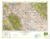
~ San Jose CA topo map, 1:250000 scale, 1 X 2 Degree, Historical, 1947, updated 1948
San Jose, California, USGS topographic map dated 1947.
Includes geographic coordinates (latitude and longitude). This topographic map is suitable for hiking, camping, and exploring, or framing it as a wall map.
Printed on-demand using high resolution imagery, on heavy weight and acid free paper, or alternatively on a variety of synthetic materials.
Topos available on paper, Waterproof, Poly, or Tyvek. Usually shipping rolled, unless combined with other folded maps in one order.
- Product Number: USGS-5506691
- Free digital map download (high-resolution, GeoPDF): San Jose, California (file size: 14 MB)
- Map Size: please refer to the dimensions of the GeoPDF map above
- Weight (paper map): ca. 55 grams
- Map Type: POD USGS Topographic Map
- Map Series: HTMC
- Map Verison: Historical
- Cell ID: 74989
- Scan ID: 707585
- Imprint Year: 1948
- Woodland Tint: Yes
- Aerial Photo Year: 1945
- Datum: NAD27
- Map Projection: Transverse Mercator
- Shaded Relief map: Yes
- Map published by United States Army Corps of Engineers
- Map published by United States Army
- Map Language: English
- Scanner Resolution: 508 dpi
- Map Cell Name: San Jose
- Grid size: 1 X 2 Degree
- Date on map: 1947
- Map Scale: 1:250000
- Geographical region: California, United States
Neighboring Maps:
All neighboring USGS topo maps are available for sale online at a variety of scales.
Spatial coverage:
Topo map San Jose, California, covers the geographical area associated the following places:
- Halley (historical) - The Willows - West Manteca - Jamestown - Carbona - Tyler (historical) - Plainsburg - Holy City - Bear Valley - Midway - Seven Trees - Alviso - Dublin - Salida - Oakley - Barrett - Sibley (historical) - Hacienda Mobile Home Park - Radum - La Grange - Lexington Hills - Mono Village - Clems (historical) - Quartz - Nortonville - English Town - Stockton - Melones Sunset Lake Estates - Diablo - Tassajara - Madrone - Centerville District - Sonora Ranchettes - Castle Gardens - Pomar (historical) - Arundel (historical) - Adobe Wells Mobile Home Park - Mountain House - Highland (historical) - Lawrence - Scotts Corner - Danville - Del Rio - Greenville (historical) - Chowchilla - Waterford - Hoff (historical) - Farwell - Manteca - Athlone - Hatch - Crows Landing - Priest - Standard - Shannon - Medano (historical) - Arastraville - Nairn (historical) - Orwood - Larson - Golden Wheeler Mobile Home Park - Blanchard - Altamont - Riverbend Family Mobile Home Park - Niles District - Buckhorn Estates - Vanormer (historical) - Sharon - Neroly - Fluhr - Claribel - Atlanta - Mobile Parks West Mobile Home Park - Sveadal - Ash (historical) - Riverdale Park - Sunol - Perry - Los Gatos Trailer Park - Willow Glen - Catheys Valley - Califa (historical) - San Jose Mobile Home Park - Greystone (historical) - Moccasin - Somersville - Burbank - Ralph - Mobilodge of Milpitas - Ellis (historical) - Remillard (historical) - Cooperstown - Agnew - Banta - Copper Cove Village - Buck Meadows - Carrolton - Peppermint Creek - Copperopolis - Groveland
- Map Area ID: AREA3837-122-120
- Northwest corner Lat/Long code: USGSNW38-122
- Northeast corner Lat/Long code: USGSNE38-120
- Southwest corner Lat/Long code: USGSSW37-122
- Southeast corner Lat/Long code: USGSSE37-120
- Northern map edge Latitude: 38
- Southern map edge Latitude: 37
- Western map edge Longitude: -122
- Eastern map edge Longitude: -120


