
~ San Jose CA topo map, 1:250000 scale, 1 X 2 Degree, Historical, 1962, updated 1971
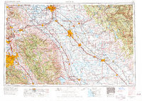
San Jose, California, USGS topographic map dated 1962.
Includes geographic coordinates (latitude and longitude). This topographic map is suitable for hiking, camping, and exploring, or framing it as a wall map.
Printed on-demand using high resolution imagery, on heavy weight and acid free paper, or alternatively on a variety of synthetic materials.
Topos available on paper, Waterproof, Poly, or Tyvek. Usually shipping rolled, unless combined with other folded maps in one order.
- Product Number: USGS-5506687
- Free digital map download (high-resolution, GeoPDF): San Jose, California (file size: 22 MB)
- Map Size: please refer to the dimensions of the GeoPDF map above
- Weight (paper map): ca. 55 grams
- Map Type: POD USGS Topographic Map
- Map Series: HTMC
- Map Verison: Historical
- Cell ID: 74989
- Scan ID: 302126
- Imprint Year: 1971
- Woodland Tint: Yes
- Aerial Photo Year: 1960
- Edit Year: 1969
- Survey Year: 1962
- Datum: Unstated
- Map Projection: Transverse Mercator
- Map published by United States Geological Survey
- Map published by: Military, Other
- Map Language: English
- Scanner Resolution: 600 dpi
- Map Cell Name: San Jose
- Grid size: 1 X 2 Degree
- Date on map: 1962
- Map Scale: 1:250000
- Geographical region: California, United States
Neighboring Maps:
All neighboring USGS topo maps are available for sale online at a variety of scales.
Spatial coverage:
Topo map San Jose, California, covers the geographical area associated the following places:
- Gustine - Planada - Harp - Campbell - Waterford - Oakley - Manteca - El Nido - Rancho Poquitos - Neroly - Hornitos - Turlock - Meridian - Hodson (historical) - Fontenay Villa - Wainwright Village - Warnerville - Livingston - Chinese Camp - Tillman (historical) - Peppermint Creek - Trigo (historical) - Holy City - Yarmouth (historical) - Alviso - Kennedy - Perry - Minturn - Carbona - Simms - Peters - Hopeton - Claribel - College Park - Buena Vista - Los Banos - Bagby - Sonora Knolls - Aurora - Rolling Hills - Femmons - East Pleasanton - Sonora Hills - Farwell - Madera Country Club Estates - Farmington - Mossdale - Mobile Parks West Mobile Home Park - The Homestead - Buhach - Stent - English Town - Niles District - Esmar (historical) - Lacto (historical) - Chemeketa Park - Sonora Ranchettes - Redwood Lodge - Winchester Ranch Mobile Home Park - Trailer Tel Mobile Home Park - French Camp - Ovejo (historical) - Tassajara - Huntley - Twin Creeks - Escalon - Meyers (historical) - Danville - Dresser - Dogtown - Asco - Priest - La Grange - Medano (historical) - Big Oak Flat - Oakdale - Calpack - Timba - Lyoth - Alma (historical) - Grayson - Sharon - Indian Gulch - Charleston (historical) - Trent - Coyote - Cochrane - Garden Acres - Avena - Parkmoor - Blackhawk - Sveadal - Mendenhall Springs - Altamont - Stockton - Summer Home - Vernalis - Ortega - Algerine - Alum Rock
- Map Area ID: AREA3837-122-120
- Northwest corner Lat/Long code: USGSNW38-122
- Northeast corner Lat/Long code: USGSNE38-120
- Southwest corner Lat/Long code: USGSSW37-122
- Southeast corner Lat/Long code: USGSSE37-120
- Northern map edge Latitude: 38
- Southern map edge Latitude: 37
- Western map edge Longitude: -122
- Eastern map edge Longitude: -120


