
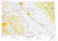
~ San Jose CA topo map, 1:250000 scale, 1 X 2 Degree, Historical, 1962, updated 1977
San Jose, California, USGS topographic map dated 1962.
Includes geographic coordinates (latitude and longitude). This topographic map is suitable for hiking, camping, and exploring, or framing it as a wall map.
Printed on-demand using high resolution imagery, on heavy weight and acid free paper, or alternatively on a variety of synthetic materials.
Topos available on paper, Waterproof, Poly, or Tyvek. Usually shipping rolled, unless combined with other folded maps in one order.
- Product Number: USGS-5506685
- Free digital map download (high-resolution, GeoPDF): San Jose, California (file size: 19 MB)
- Map Size: please refer to the dimensions of the GeoPDF map above
- Weight (paper map): ca. 55 grams
- Map Type: POD USGS Topographic Map
- Map Series: HTMC
- Map Verison: Historical
- Cell ID: 74989
- Scan ID: 302125
- Imprint Year: 1977
- Woodland Tint: Yes
- Visual Version Number: 1
- Aerial Photo Year: 1960
- Edit Year: 1969
- Field Check Year: 1962
- Datum: Unstated
- Map Projection: Transverse Mercator
- Map published by United States Geological Survey
- Map published by: Military, Other
- Map Language: English
- Scanner Resolution: 600 dpi
- Map Cell Name: San Jose
- Grid size: 1 X 2 Degree
- Date on map: 1962
- Map Scale: 1:250000
- Geographical region: California, United States
Neighboring Maps:
All neighboring USGS topo maps are available for sale online at a variety of scales.
Spatial coverage:
Topo map San Jose, California, covers the geographical area associated the following places:
- Mountain House - Fairway Acres - Bystrom - Santa Clara Trailer Village - San Martin - Hornitos - The Shores of Poker Flat - Lexington (historical) - Trent - Ash (historical) - Drawbridge (historical) - Trigo (historical) - Warm Springs District - El Pinal - Dublin - Planada - Sonora Ranchettes - Barrett - Diablo - Carrolton - Madera Country Club Estates - Wayne - Le Grand - San Jose - Lingard - Stewartville - Snoboy - Scenic Brook - Pomar (historical) - Lonoke - Seven Trees - Diablo Grande - Newlove - Linora (historical) - Turner - Brightside - Tillman (historical) - Vasona Junction - Hoff (historical) - Bear Creek - Robertsville - Oakley - Hayward - Ripon - Paulsell - Guadalupe (historical) - El Nido - Plains (historical) - Second Garrotte - Ellis (historical) - Hughson - Kilkare Woods - Walthal - Tuolumne - Milpitas Mobile Home Park - Riverdale Park - Mission San Jose District - Madera Highlands - Greeley Hill - Agua Fria - English Town - Somersville - Redwood Estates - Amsterdam - McHenry - Lamplighter Mobile Home Park - Agnew - Park Sierra Mobile Home Park - Marsh Creek Springs - San Ramon - Manteca Junction - Redwood Lodge - Fair Oaks - Aurora - Rucker - Oak Gardens Estates - Stent - Rock City - Harp - Danville - Ralph - Day Valley - Blanchard - Catheys Valley - Glenwood - The Grove - Standard - Cuesta Serena - Scenic View - Cochrane - Abbato (historical) - Los Gatos - Sunol - Los Banos - Dos Palos Y - Colfax Spring - Burnham - La Grange - Fluhr - Buck Meadows
- Map Area ID: AREA3837-122-120
- Northwest corner Lat/Long code: USGSNW38-122
- Northeast corner Lat/Long code: USGSNE38-120
- Southwest corner Lat/Long code: USGSSW37-122
- Southeast corner Lat/Long code: USGSSE37-120
- Northern map edge Latitude: 38
- Southern map edge Latitude: 37
- Western map edge Longitude: -122
- Eastern map edge Longitude: -120


