
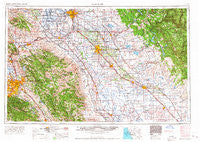
~ San Jose CA topo map, 1:250000 scale, 1 X 2 Degree, Historical, 1966, updated 1966
San Jose, California, USGS topographic map dated 1966.
Includes geographic coordinates (latitude and longitude). This topographic map is suitable for hiking, camping, and exploring, or framing it as a wall map.
Printed on-demand using high resolution imagery, on heavy weight and acid free paper, or alternatively on a variety of synthetic materials.
Topos available on paper, Waterproof, Poly, or Tyvek. Usually shipping rolled, unless combined with other folded maps in one order.
- Product Number: USGS-5506683
- Free digital map download (high-resolution, GeoPDF): San Jose, California (file size: 22 MB)
- Map Size: please refer to the dimensions of the GeoPDF map above
- Weight (paper map): ca. 55 grams
- Map Type: POD USGS Topographic Map
- Map Series: HTMC
- Map Verison: Historical
- Cell ID: 74989
- Scan ID: 302124
- Imprint Year: 1966
- Woodland Tint: Yes
- Field Check Year: 1962
- Datum: Unstated
- Map Projection: Transverse Mercator
- Map published by United States Army Corps of Engineers
- Map published by United States Army
- Map Language: English
- Scanner Resolution: 600 dpi
- Map Cell Name: San Jose
- Grid size: 1 X 2 Degree
- Date on map: 1966
- Map Scale: 1:250000
- Geographical region: California, United States
Neighboring Maps:
All neighboring USGS topo maps are available for sale online at a variety of scales.
Spatial coverage:
Topo map San Jose, California, covers the geographical area associated the following places:
- College Park - San Jose Mobile Home Park - Medano (historical) - Monte Sereno - Sand Hill - Second Garrotte - Campo Seco - Vineyard Mobile Villa - Charleston (historical) - Tuolumne City - Lonoke - Lick - Harp - Van Allen - Patterson - Los Gatos - Edendale (historical) - Irvington District - Hayward - East Sonora - Brightside - Centerville District - Hetch Hetchy Junction - Mossdale - Heinlenville (historical) - Calla - Highland (historical) - South Coyote - Lawrence - Tassajara - Newman - Sonora Hills - Casa Amigo Mobile Home Park - Avena - Willow Glen - Yosemite Junction - Cochrane - The Homestead - Santa Clara Trailer Village - Valley Home - Tuttletown - Guadalupe (historical) - Buhach - Ashrama - Scenic Brook - Berryessa - Ash (historical) - Moccasin - Santa Rita Park - Quail Hollow - Madrone - Irwin - Pomar (historical) - Snelling - Tillman (historical) - San Martin - Buchanan - Hornitos - Alum Rock - Castle Gardens - The Grove - Campbell - Mono Vista - Redwood Lodge - Alma (historical) - Vernalis - Turlock - Marguerite (historical) - Bardi - Vanormer (historical) - La Grange - Trent - Dickenson (historical) - Roundup Trailer Lodge - Kismet - Orford - Orwood - Hickman - East Pleasanton - Trull - Ellis (historical) - August - Asco - Camino Tassajara - Walthal - Rawhide - Paulsell - Plains (historical) - Sunol - Mountain House - Aldercroft Heights - Warm Springs District - Shannon - Amsterdam - Sunshine Camp - Mobile Parks West Mobile Home Park - Copper Cove Village - New Almaden - Valley Lake Ranchos - Jet
- Map Area ID: AREA3837-122-120
- Northwest corner Lat/Long code: USGSNW38-122
- Northeast corner Lat/Long code: USGSNE38-120
- Southwest corner Lat/Long code: USGSSW37-122
- Southeast corner Lat/Long code: USGSSE37-120
- Northern map edge Latitude: 38
- Southern map edge Latitude: 37
- Western map edge Longitude: -122
- Eastern map edge Longitude: -120


