
~ San Jose CA topo map, 1:250000 scale, 1 X 2 Degree, Historical, 1962, updated 1962
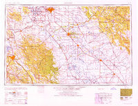
San Jose, California, USGS topographic map dated 1962.
Includes geographic coordinates (latitude and longitude). This topographic map is suitable for hiking, camping, and exploring, or framing it as a wall map.
Printed on-demand using high resolution imagery, on heavy weight and acid free paper, or alternatively on a variety of synthetic materials.
Topos available on paper, Waterproof, Poly, or Tyvek. Usually shipping rolled, unless combined with other folded maps in one order.
- Product Number: USGS-5506681
- Free digital map download (high-resolution, GeoPDF): San Jose, California (file size: 16 MB)
- Map Size: please refer to the dimensions of the GeoPDF map above
- Weight (paper map): ca. 55 grams
- Map Type: POD USGS Topographic Map
- Map Series: HTMC
- Map Verison: Historical
- Cell ID: 74989
- Scan ID: 302123
- Imprint Year: 1962
- Woodland Tint: Yes
- Aerial Photo Year: 1945
- Datum: Unstated
- Map Projection: Transverse Mercator
- Map published by United States Army Corps of Engineers
- Map published by United States Army
- Map Language: English
- Scanner Resolution: 600 dpi
- Map Cell Name: San Jose
- Grid size: 1 X 2 Degree
- Date on map: 1962
- Map Scale: 1:250000
- Geographical region: California, United States
Neighboring Maps:
All neighboring USGS topo maps are available for sale online at a variety of scales.
Spatial coverage:
Topo map San Jose, California, covers the geographical area associated the following places:
- Meyers (historical) - Riverside - Ingomar - San Joaquin River Club - East Sonora - Lawrence - Austin - Escalon - Volponi Acres - Hoff (historical) - Trent - Huntley - Tuolumne - Abbato (historical) - Quito (historical) - The Grove - Algerine - Lincoln (historical) - Standiford - Bystrom - Santa Clara - Burbank - Chinatown (historical) - Alamitos - Wainwright Village - Newlove - Vanormer (historical) - Burchell (historical) - Manteca - San Ramon - Stockton - Coulterville - Hornitos - Minturn - Holden (historical) - Fremont - Cochrane - Tracy - Newman - Paulsell - Wayne - Carbona - Dairyland - Merced Falls - Los Gatos - Cortez - Diablo Grande - Lingard - Alviso - Irvington District - Nairn (historical) - Akers - Empire - Tassajara - Sonora - English Town - Solyo - Golden Wheeler Mobile Home Park - Ohm - San Ramon Village - Bixler - Danville - Buena Vista - Redwood Lodge - Rucker - Arundel (historical) - Turlock - Willow Glen - Priest - Cooperstown - French Camp - Blackslough Landing - Morgan Hill - Calpack - Ceres - Livingston - Gustine - Stewart (historical) - Copper Cove Subdivision - Merienda (historical) - Fluhr - Groveland - North McHenry - Shackelford - Eugene - Pomar (historical) - Cuesta Serena - Trailer Tel Mobile Home Park - Arnold (historical) - Cuba (historical) - Alba - Quail Ridge Ranch - Centerville District - Trevarno - Lyoth - Mendenhall Springs - Denair - Sand Hill - Brentwood - Garden City Trailer Court
- Map Area ID: AREA3837-122-120
- Northwest corner Lat/Long code: USGSNW38-122
- Northeast corner Lat/Long code: USGSNE38-120
- Southwest corner Lat/Long code: USGSSW37-122
- Southeast corner Lat/Long code: USGSSE37-120
- Northern map edge Latitude: 38
- Southern map edge Latitude: 37
- Western map edge Longitude: -122
- Eastern map edge Longitude: -120


