
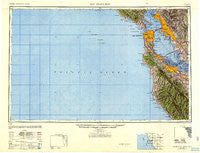
~ San Francisco CA topo map, 1:250000 scale, 1 X 2 Degree, Historical, 1947, updated 1948
San Francisco, California, USGS topographic map dated 1947.
Includes geographic coordinates (latitude and longitude). This topographic map is suitable for hiking, camping, and exploring, or framing it as a wall map.
Printed on-demand using high resolution imagery, on heavy weight and acid free paper, or alternatively on a variety of synthetic materials.
Topos available on paper, Waterproof, Poly, or Tyvek. Usually shipping rolled, unless combined with other folded maps in one order.
- Product Number: USGS-5506677
- Free digital map download (high-resolution, GeoPDF): San Francisco, California (file size: 22 MB)
- Map Size: please refer to the dimensions of the GeoPDF map above
- Weight (paper map): ca. 55 grams
- Map Type: POD USGS Topographic Map
- Map Series: HTMC
- Map Verison: Historical
- Cell ID: 69014
- Scan ID: 707582
- Imprint Year: 1948
- Woodland Tint: Yes
- Aerial Photo Year: 1945
- Datum: NAD27
- Map Projection: Transverse Mercator
- Special Map: Yes
- Map published by United States Geological Survey
- Map published by United States Army Corps of Engineers
- Map published by United States Army
- Map Language: English
- Scanner Resolution: 508 dpi
- Map Cell Name: San Francisco
- Grid size: 1 X 2 Degree
- Date on map: 1947
- Map Scale: 1:250000
- Geographical region: California, United States
Neighboring Maps:
All neighboring USGS topo maps are available for sale online at a variety of scales.
Spatial coverage:
Topo map San Francisco, California, covers the geographical area associated the following places:
- Ladera - Jarvis Landing - Eastmont - Easter Hill Village - Orinda Village - Butano Park - Seacliff - Eldton - Lloyden Park - Merced Heights - Searsville (historical) - Park Merced - Pescadero - El Campo - Adams Point - Bolinas - Muir Beach - Claremont - Moss Beach - Fair Oaks - Sherwood Forest - Gemello - San Anselmo - Woodside Highlands - Fruitvale - Four Corners - Chinatown - Vintage Oaks - East Richmond - Village Square - Normandy Village - Loren Miller Homes - West Berkeley - Redwood City Mobile Home Park - Lafayette - Park Forest - Palo Alto Orchards - Larkspur - Raines Houses - Saint Claire Gardens - Newark - Reed - Blue Hills - Campbell Village - Cuernavaca - Sydney Town (historical) - Forest Hill - Redwood Mobile Home Park - The Highlands - Sorenson - Sky Londa - Union City - Westborough - Rollingwood - Pacifica - Broadmoor - Pacheco - Leland Manor - Millbrae Meadows - Fairview - Daly City - San Quentin - Charleston Gardens - Pedro Valley - Millsmont - College Terrace - Belvedere Island - Leona Heights - Forest Springs - Paradise Cay - Alta Mesa - Escondido Village - Cape Cod Village Mobile Home Park - Santiago Villa Mobile Home Park - Redwood Junction - Fairway Park - Piedmont - Sahara Village Mobile Home Park - Adobe Meadow - Rincon - Fairoaks Mobile Home Park - Millbrae - Seminary Park - Palomar Park - Lindenwood - Runnymeade (historical) - Vista Verde - Victoria Mews - Embarcadero Oaks - Camp Evers - Homestead Valley - Rochedale Village - Tamalpais Valley Junction - Los Trancos Woods - Half Moon Bay - Hayward Park - Glenridge - Brookdale - Opera Plaza - Stanford Park
- Map Area ID: AREA3837-124-122
- Northwest corner Lat/Long code: USGSNW38-124
- Northeast corner Lat/Long code: USGSNE38-122
- Southwest corner Lat/Long code: USGSSW37-124
- Southeast corner Lat/Long code: USGSSE37-122
- Northern map edge Latitude: 38
- Southern map edge Latitude: 37
- Western map edge Longitude: -124
- Eastern map edge Longitude: -122


