
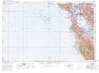
~ San Francisco CA topo map, 1:250000 scale, 1 X 2 Degree, Historical, 1956, updated 1980
San Francisco, California, USGS topographic map dated 1956.
Includes geographic coordinates (latitude and longitude). This topographic map is suitable for hiking, camping, and exploring, or framing it as a wall map.
Printed on-demand using high resolution imagery, on heavy weight and acid free paper, or alternatively on a variety of synthetic materials.
Topos available on paper, Waterproof, Poly, or Tyvek. Usually shipping rolled, unless combined with other folded maps in one order.
- Product Number: USGS-5506675
- Free digital map download (high-resolution, GeoPDF): San Francisco, California (file size: 22 MB)
- Map Size: please refer to the dimensions of the GeoPDF map above
- Weight (paper map): ca. 55 grams
- Map Type: POD USGS Topographic Map
- Map Series: HTMC
- Map Verison: Historical
- Cell ID: 69014
- Scan ID: 302120
- Imprint Year: 1980
- Woodland Tint: Yes
- Aerial Photo Year: 1978
- Edit Year: 1980
- Field Check Year: 1956
- Datum: NAD27
- Map Projection: Transverse Mercator
- Map published by United States Geological Survey
- Map Language: English
- Scanner Resolution: 600 dpi
- Map Cell Name: San Francisco
- Grid size: 1 X 2 Degree
- Date on map: 1956
- Map Scale: 1:250000
- Geographical region: California, United States
Neighboring Maps:
All neighboring USGS topo maps are available for sale online at a variety of scales.
Spatial coverage:
Topo map San Francisco, California, covers the geographical area associated the following places:
- San Lorenzo - Daly City - Rancho Rinconada - Moss Beach - San Pedro Terrace - Fair Oaks - La Loma Park - Seal Cove - Paradise Park - Cherryland - Sequoia Mobile Home Park - Merced Heights - West Menlo Park - Montalvin - Trestle Glen - Felton Gables - Ingleside Heights - Meadow Park - Stanford Weekend Acres - Accent Homes Mobile Home Park - Atchison Village - Berkeley - South San Francisco - El Granada Mobile Home Park - Davenport - Willow Ranch Mobile Home Park - University Heights - Golden Gate Heights - Stinson Beach - Pacific Skies Mobile Home Park - Lompico - Merced Manor - Opera Plaza - Melrose - Valle Vista - Park View Commons - Tara Hills - Woodside - Oakland - Hookston - El Cerrito - South Berkeley - Harbor Point - Fort Winfield Scott - Bellvale - Sholun - Charleston Gardens - Stanford - The Willows - Tamalpais Valley Junction - Sharon Heights - Belle Haven - Sunny Acres Trailer Park - Marin City - Kentfield - Russell City - Saint Francis - Paradise Cay - Escondido Village - Oceanview - Eastport - South Shore - Pacheco - Redwood Shores - Fernside - Carpenter - Pasatiempo - Richmond - Newark - Lobitos - Muir - Highland Park - Tamalpais Valley - Pierce Mitchell Houses - Ravenswood - El Granada - Hillsborough Park - Highlands - San Bruno - Rockridge - Walnut Heights - Crocker Highlands - Bolinas - Raines Houses - Monta Loma - Leland Manor - Murray Park - Beulah Park - Woodside Highlands - Champagne Fountain - Boulder Creek - Redwood Mobile Home Park - Sorenson - Pleasant Hill - Potrero District - Sydney Town (historical) - Ross - Redwood Grove - Purisima (historical) - Havenscourt
- Map Area ID: AREA3837-124-122
- Northwest corner Lat/Long code: USGSNW38-124
- Northeast corner Lat/Long code: USGSNE38-122
- Southwest corner Lat/Long code: USGSSW37-124
- Southeast corner Lat/Long code: USGSSE37-122
- Northern map edge Latitude: 38
- Southern map edge Latitude: 37
- Western map edge Longitude: -124
- Eastern map edge Longitude: -122


