
~ San Francisco CA topo map, 1:250000 scale, 1 X 2 Degree, Historical, 1956, updated 1976
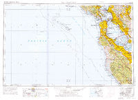
San Francisco, California, USGS topographic map dated 1956.
Includes geographic coordinates (latitude and longitude). This topographic map is suitable for hiking, camping, and exploring, or framing it as a wall map.
Printed on-demand using high resolution imagery, on heavy weight and acid free paper, or alternatively on a variety of synthetic materials.
Topos available on paper, Waterproof, Poly, or Tyvek. Usually shipping rolled, unless combined with other folded maps in one order.
- Product Number: USGS-5506673
- Free digital map download (high-resolution, GeoPDF): San Francisco, California (file size: 16 MB)
- Map Size: please refer to the dimensions of the GeoPDF map above
- Weight (paper map): ca. 55 grams
- Map Type: POD USGS Topographic Map
- Map Series: HTMC
- Map Verison: Historical
- Cell ID: 69014
- Scan ID: 302119
- Imprint Year: 1976
- Woodland Tint: Yes
- Aerial Photo Year: 1952
- Edit Year: 1969
- Field Check Year: 1956
- Datum: Unstated
- Map Projection: Transverse Mercator
- Map published by United States Army Corps of Engineers
- Map published by United States Army
- Map Language: English
- Scanner Resolution: 600 dpi
- Map Cell Name: San Francisco
- Grid size: 1 X 2 Degree
- Date on map: 1956
- Map Scale: 1:250000
- Geographical region: California, United States
Neighboring Maps:
All neighboring USGS topo maps are available for sale online at a variety of scales.
Spatial coverage:
Topo map San Francisco, California, covers the geographical area associated the following places:
- Crocker Highlands - University Heights - Monta Loma - Fairoaks Mobile Home Park - Pacific Skies Mobile Home Park - Mountain View - Pabrico - Marina District - Normandy Village - Cherryland - Sunset District - Ingleside - Carpenter - Kensington - Hayward Park - Mission Springs - Saint Francis Wood - Rancho Rinconada - Millbrae Meadows - Escondido Village - Presidio Terrace - Doelger City - Ladera - San Anselmo - Fort Winfield Scott - Sharon Heights - Seal Cove - Broadmoor Village - Redwood Trailer Village - Nystrom Village - Lockwood Gardens - Monta Vista - Meinert - Beulah Park - Los Ranchitos - Pacific Heights - Valencia Gardens - Bancroft - Kentfield - Almonte - Stanford Hills - Henderson - Davenport Landing - Tiburon - Sunny Acres Trailer Park - Cupertino - Castro City - East Palo Alto - Bracken Brae - Alamo - Escalle - Newark - Red Arrow Mobile Home Park - Stanford Weekend Acres - Colma - South Shore - Brookfield Village - College Terrace - Trailer Villa Mobile Home Park - Palomar Park - Brookdale - Pacifica - Jarvis Landing - Riverside Grove - Dimond District - South Shore Port - Forest Knolls - North Richmond - Jackson Park - Pacheco - Daly City - Stonestown - Hillsborough - Farm Hills - Redwood Grove - Leona Heights - Burlingame - Santa Venetia - Embarcadero Oaks - Westridge - Scotts Valley - Leland Manor - Sausalito - Raines Houses - Pedro Valley - Moraga - Woodside Highlands - Havenscourt - Waverly Park - Mary Manor Mobile Estates - San Lorenzo Park - Meadowsweet - Professorville - Plaza del Rey Mobile Home Park - Rices Junction - Andry Mobile Home Park - Martins Beach - Mount Hermon - Aloha Mobile Village - Saint Francis
- Map Area ID: AREA3837-124-122
- Northwest corner Lat/Long code: USGSNW38-124
- Northeast corner Lat/Long code: USGSNE38-122
- Southwest corner Lat/Long code: USGSSW37-124
- Southeast corner Lat/Long code: USGSSE37-122
- Northern map edge Latitude: 38
- Southern map edge Latitude: 37
- Western map edge Longitude: -124
- Eastern map edge Longitude: -122


