
~ San Francisco CA topo map, 1:250000 scale, 1 X 2 Degree, Historical, 1961, updated 1961
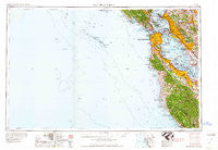
San Francisco, California, USGS topographic map dated 1961.
Includes geographic coordinates (latitude and longitude). This topographic map is suitable for hiking, camping, and exploring, or framing it as a wall map.
Printed on-demand using high resolution imagery, on heavy weight and acid free paper, or alternatively on a variety of synthetic materials.
Topos available on paper, Waterproof, Poly, or Tyvek. Usually shipping rolled, unless combined with other folded maps in one order.
- Product Number: USGS-5506667
- Free digital map download (high-resolution, GeoPDF): San Francisco, California (file size: 12 MB)
- Map Size: please refer to the dimensions of the GeoPDF map above
- Weight (paper map): ca. 55 grams
- Map Type: POD USGS Topographic Map
- Map Series: HTMC
- Map Verison: Historical
- Cell ID: 69014
- Scan ID: 302116
- Imprint Year: 1961
- Woodland Tint: Yes
- Field Check Year: 1956
- Datum: Unstated
- Map Projection: Transverse Mercator
- Map published by United States Army Corps of Engineers
- Map published by United States Army
- Map Language: English
- Scanner Resolution: 600 dpi
- Map Cell Name: San Francisco
- Grid size: 1 X 2 Degree
- Date on map: 1961
- Map Scale: 1:250000
- Geographical region: California, United States
Neighboring Maps:
All neighboring USGS topo maps are available for sale online at a variety of scales.
Spatial coverage:
Topo map San Francisco, California, covers the geographical area associated the following places:
- Oakland - Laurel - Alamo - Blossom Valley - Saratoga - Woodside Glens - Ben Lomond - Charleston Gardens - Daly City - Blue Hills - Cherryland - Walnut Heights - Le Mar Mobile Home Park - Woodside - Little Osaka - San Anselmo - La Loma Park - Palo Alto Orchards - The Willows - Orinda Village - Cerro - Trestle Glen - West Berkeley - Atchison Village - Broadmoor - Stanford - Palomar Park - El Cerrito - South Shore - Waldo - Hilarita - Greenbrae - Moraga - Swanton - Baden - Malcolm X Square - Olympia - Stanford Hills - Strawberry Manor - Contra Costa Centre - Baywood Park - Castro City - The Greenhouse - West Oakland - Redwood City - Pacific Skies Mobile Home Park - Andry Mobile Home Park - Ravenswood - Vista Del Monte - New Frontier Mobile Home Park - Los Ranchitos - Colma - Meinert - Embarcadero Oaks - Stege - Murray Park - Bellvale - Maxwell Park - Fairview - Travelodge Mobile Home Park - Evergreen Park - Ingleside Terrace - Edgemar - Crocker Highlands - Belle Haven - Giant - Sahara Village Mobile Home Park - Butano Park - Waldon - Duveneck - Cuesta Park - Reed - Lorenzo Station - Millsmont - Moffett Trailer Village - Vintage Oaks - Pacific Manor - Canyon - Corte Madera - Rancho Rinconada - Sylvan Park - Eldton - Friendship Village - Lafayette - Saint Francis Acres - Waverly Park - Menlo Oaks - Spanish Ranch Mobile Home Park - Glorietta - South Berkeley - Carpenter - Campbell Village - Adobe Corner - Hookston - Montara - Sunset Estates Mobile Home Park - Bolinas - Russell City - Silver Terrace - Glen Arbor
- Map Area ID: AREA3837-124-122
- Northwest corner Lat/Long code: USGSNW38-124
- Northeast corner Lat/Long code: USGSNE38-122
- Southwest corner Lat/Long code: USGSSW37-124
- Southeast corner Lat/Long code: USGSSE37-122
- Northern map edge Latitude: 38
- Southern map edge Latitude: 37
- Western map edge Longitude: -124
- Eastern map edge Longitude: -122


