
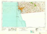
~ San Diego CA topo map, 1:250000 scale, 1 X 2 Degree, Historical, 1958, updated 1961
San Diego, California, USGS topographic map dated 1958.
Includes geographic coordinates (latitude and longitude). This topographic map is suitable for hiking, camping, and exploring, or framing it as a wall map.
Printed on-demand using high resolution imagery, on heavy weight and acid free paper, or alternatively on a variety of synthetic materials.
Topos available on paper, Waterproof, Poly, or Tyvek. Usually shipping rolled, unless combined with other folded maps in one order.
- Product Number: USGS-5506655
- Free digital map download (high-resolution, GeoPDF): San Diego, California (file size: 12 MB)
- Map Size: please refer to the dimensions of the GeoPDF map above
- Weight (paper map): ca. 55 grams
- Map Type: POD USGS Topographic Map
- Map Series: HTMC
- Map Verison: Historical
- Cell ID: 69013
- Scan ID: 299879
- Imprint Year: 1961
- Woodland Tint: Yes
- Aerial Photo Year: 1956
- Field Check Year: 1958
- Datum: Unstated
- Map Projection: Transverse Mercator
- Map published by United States Army Corps of Engineers
- Map published by United States Army
- Map Language: English
- Scanner Resolution: 600 dpi
- Map Cell Name: San Diego
- Grid size: 1 X 2 Degree
- Date on map: 1958
- Map Scale: 1:250000
- Geographical region: California, United States
Neighboring Maps:
All neighboring USGS topo maps are available for sale online at a variety of scales.
Spatial coverage:
Topo map San Diego, California, covers the geographical area associated the following places:
- Easter Cross - Doghouse Junction - La Jolla Hermosa - El Capitan (historical) - Logan Heights - Otay Mesa - Hacienda del Florasol - Clover Flat - Shady Dell - Camerons Mobile Home Park - Laguna Junction - Town and Country Mobile Home Park - Del Mar Heights - Palm Grove - Chula Vista - Descanso Junction - Paradise Hills - Valencia Park - Coronado Heights (historical) - Barona - Homelands - Lomita - Alpine - Sunny Vista - Coronado - North Park - South Bay Terraces - Pine Grove - La Mesa - Boulder Oaks - Bostonia - North Bay Terraces - Guatay - Santee - Grant Hill - Cameron Corners - Mission Beach - South Crest - Riverview - Eden Gardens - Eastlake Greens - South Encantato - Mussey Grove (historical) - Otay - North Clairemont - Mount Hope - New Frontier Mobile Home Park - Tierra del Sol - Dulzura - College Heights - Boulder Oaks - Riviera Villas - Lynwood Hills - Allied Gardens - Sunset Cliffs - Lakeside Farms - Fiesta Shores - Hulburd Grove - The Willows - Descanso - Bonita - Suncrest - Lincoln Acres - Lemon Grove - La Cresta - Winter Gardens - Potrero - Old Town San Diego - Del Cerro - Titus - Highlands Mobile Home Park - Johnstown - Fort Rosecrans - Flinn Springs - Barrio Logan - Roseville - Mount Laguna - Casa de Oro - La Playa - Village Green Trailer Park - Mira Mesa - Hillcrest - Morena - Jamacha - Canyon City - Chollas View - Phelps Corner - East San Diego - Boal - Chollas Creek - Campland on the Bay Trailer Park - Jamacha Junction - Bayside Village - Manzanita - South Park - Stallion Oaks - Del Mar - University Heights - Sorrento - Imperial Beach
- Map Area ID: AREA3332-118-116
- Northwest corner Lat/Long code: USGSNW33-118
- Northeast corner Lat/Long code: USGSNE33-116
- Southwest corner Lat/Long code: USGSSW32-118
- Southeast corner Lat/Long code: USGSSE32-116
- Northern map edge Latitude: 33
- Southern map edge Latitude: 32
- Western map edge Longitude: -118
- Eastern map edge Longitude: -116


