
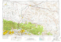
~ San Bernardino CA topo map, 1:250000 scale, 1 X 2 Degree, Historical, 1958, updated 1975
San Bernardino, California, USGS topographic map dated 1958.
Includes geographic coordinates (latitude and longitude). This topographic map is suitable for hiking, camping, and exploring, or framing it as a wall map.
Printed on-demand using high resolution imagery, on heavy weight and acid free paper, or alternatively on a variety of synthetic materials.
Topos available on paper, Waterproof, Poly, or Tyvek. Usually shipping rolled, unless combined with other folded maps in one order.
- Product Number: USGS-5506649
- Free digital map download (high-resolution, GeoPDF): San Bernardino, California (file size: 19 MB)
- Map Size: please refer to the dimensions of the GeoPDF map above
- Weight (paper map): ca. 55 grams
- Map Type: POD USGS Topographic Map
- Map Series: HTMC
- Map Verison: Historical
- Cell ID: 69012
- Scan ID: 299874
- Imprint Year: 1975
- Woodland Tint: Yes
- Aerial Photo Year: 1968
- Edit Year: 1969
- Field Check Year: 1958
- Datum: Unstated
- Map Projection: Transverse Mercator
- Map published by: Military, Other
- Map Language: English
- Scanner Resolution: 600 dpi
- Map Cell Name: San Bernardino
- Grid size: 1 X 2 Degree
- Date on map: 1958
- Map Scale: 1:250000
- Geographical region: California, United States
Neighboring Maps:
All neighboring USGS topo maps are available for sale online at a variety of scales.
Spatial coverage:
Topo map San Bernardino, California, covers the geographical area associated the following places:
- Skyforest - Blue Jay - Klondike - Charter Oak Mobile Estates - Las Uvas (historical) - Big Bear City - Hector - Sugarloaf - Guasti - Arrowbear Lake - Lake Los Angeles - Kenton Mill - Avocado Heights - Baldwin Park - Houze Place - Diamond Bar - Minneola - Covina - Champagne - Devil Canyon - Ontario - Redman - Bryman - Lone Wolf Colony - Ash Hill - Lenwood - Apple Valley - Lavic - Declezville - Amber Hills - Piñon Hills - Upland - Rich - Barstow Heights - Sierra Heights - South Adelanto - Molino - Walnut - Scotland - Pomona Islander Mobile Home Park - Deer Haven - Twin Peaks - Jimgrey - Valinda - Narod - Hi Vista - Valyermo - Ballou - East Colton Heights - Leon - Forest Falls - Highgrove - Boulder Bay - Pisgah - Toomey - Bethune - Newberry Springs - Glen Avon - Mace (historical) - Rimforest - Grand Terrace - Hesperia - Kramer - Ranchos del Oro - Pinto Wye - West Covina - Montclair - The Plaza - Cedar Springs (historical) - San Antonio Heights - Largo Vista - Cajon - Crestline - Grandview - Edwards - Etiwanda - Mountain Home Village - Rialto - Redlands Heights - Cushenbury - Victoria - Eagle Ranch - Duncan Corners - Joshua Tree - Cotners Corner - Crown Jewel - Azusa - Glendora - North Barstow - Arrowhead Highlands - Highland - Seven Oaks - Desert Relief (historical) - Fredalba - Chino - Mound City (historical) - Mount Baldy - Walnut Hills Mobile Home Park - Morongo Valley - The Mesa
- Map Area ID: AREA3534-118-116
- Northwest corner Lat/Long code: USGSNW35-118
- Northeast corner Lat/Long code: USGSNE35-116
- Southwest corner Lat/Long code: USGSSW34-118
- Southeast corner Lat/Long code: USGSSE34-116
- Northern map edge Latitude: 35
- Southern map edge Latitude: 34
- Western map edge Longitude: -118
- Eastern map edge Longitude: -116


