
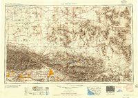
~ San Bernardino CA topo map, 1:250000 scale, 1 X 2 Degree, Historical, 1953, updated 1954
San Bernardino, California, USGS topographic map dated 1953.
Includes geographic coordinates (latitude and longitude). This topographic map is suitable for hiking, camping, and exploring, or framing it as a wall map.
Printed on-demand using high resolution imagery, on heavy weight and acid free paper, or alternatively on a variety of synthetic materials.
Topos available on paper, Waterproof, Poly, or Tyvek. Usually shipping rolled, unless combined with other folded maps in one order.
- Product Number: USGS-5506641
- Free digital map download (high-resolution, GeoPDF): San Bernardino, California (file size: 22 MB)
- Map Size: please refer to the dimensions of the GeoPDF map above
- Weight (paper map): ca. 55 grams
- Map Type: POD USGS Topographic Map
- Map Series: HTMC
- Map Verison: Historical
- Cell ID: 69012
- Scan ID: 299870
- Imprint Year: 1954
- Datum: Unstated
- Map Projection: Transverse Mercator
- Shaded Relief map: Yes
- Map published by United States Army Corps of Engineers
- Map published by United States Army
- Map Language: English
- Scanner Resolution: 600 dpi
- Map Cell Name: San Bernardino
- Grid size: 1 X 2 Degree
- Date on map: 1953
- Map Scale: 1:250000
- Geographical region: California, United States
Neighboring Maps:
All neighboring USGS topo maps are available for sale online at a variety of scales.
Spatial coverage:
Topo map San Bernardino, California, covers the geographical area associated the following places:
- Monrovia - Helendale - Thorn - Ormand - Guasti - Crestline - Nevada - Adelanto - Stalder - Rancho Cucamonga - Charter Oak - Upland - Las Lomas - Highgrove - The Mesa - Sunnyslope - Skyforest - Eagle Ranch - Sunsweet - South Fontana - Llano - El Mirage - Manix - Mountain View Acres - Rimrock - Sierra Heights - Arrowhead Farms - Morongo Valley - Henshaw - Glen Martin - Cajon - Crafton - Pisgah - Jimgrey - Walnut Hills Mobile Home Park - Frost - Spring Valley Lake - Mace (historical) - Cedar Springs (historical) - La Fetra - Loma Linda - Nebo - Barstow - Antelope Center - Azusa - Puente Junction - Boron - Rana - Grandview - Harvard - Bassett - Glen Avon - Cushenbury - Verdemont - Bethune - South San Jose Hills - Claremont - Greentree East - Argos - Racimo - Pomona - Sunset Hills - Lavic - Irwindale - North Ontario - Fizzben Heights - Valinda - Agua Fria - Ash Hill - Skyline North - Meadowbrook Woods - East Highlands - Doble - Desert View Housing Area - Yucca Inn - Pomona Islander Mobile Home Park - Running Springs - Cajon Junction - Los Olivos - Baldy Mesa - Apple Valley Highlands - Boulder Bay - Pinto Wye - Wherry Housing - Redlands - Valencia - Lone Wolf Colony - Pinezanita - Mile High - Orange Avenue Junction - Ballou - Etiwa (historical) - Cottage Gardens - Mariana Ranchos - Desert Relief (historical) - Sunfair Heights - Grand Terrace - Duncan Corners - Harlem Springs - Covina
- Map Area ID: AREA3534-118-116
- Northwest corner Lat/Long code: USGSNW35-118
- Northeast corner Lat/Long code: USGSNE35-116
- Southwest corner Lat/Long code: USGSSW34-118
- Southeast corner Lat/Long code: USGSSE34-116
- Northern map edge Latitude: 35
- Southern map edge Latitude: 34
- Western map edge Longitude: -118
- Eastern map edge Longitude: -116


