
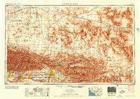
~ San Bernardino CA topo map, 1:250000 scale, 1 X 2 Degree, Historical, 1956, updated 1956
San Bernardino, California, USGS topographic map dated 1956.
Includes geographic coordinates (latitude and longitude). This topographic map is suitable for hiking, camping, and exploring, or framing it as a wall map.
Printed on-demand using high resolution imagery, on heavy weight and acid free paper, or alternatively on a variety of synthetic materials.
Topos available on paper, Waterproof, Poly, or Tyvek. Usually shipping rolled, unless combined with other folded maps in one order.
- Product Number: USGS-5506639
- Free digital map download (high-resolution, GeoPDF): San Bernardino, California (file size: 23 MB)
- Map Size: please refer to the dimensions of the GeoPDF map above
- Weight (paper map): ca. 55 grams
- Map Type: POD USGS Topographic Map
- Map Series: HTMC
- Map Verison: Historical
- Cell ID: 69012
- Scan ID: 299869
- Imprint Year: 1956
- Datum: Unstated
- Map Projection: Transverse Mercator
- Shaded Relief map: Yes
- Map published by United States Army Corps of Engineers
- Map published by United States Army
- Map Language: English
- Scanner Resolution: 600 dpi
- Map Cell Name: San Bernardino
- Grid size: 1 X 2 Degree
- Date on map: 1956
- Map Scale: 1:250000
- Geographical region: California, United States
Neighboring Maps:
All neighboring USGS topo maps are available for sale online at a variety of scales.
Spatial coverage:
Topo map San Bernardino, California, covers the geographical area associated the following places:
- Crestmore - Apple Valley - West Covina - Etiwanda - The Village - Victorville - Yucaipa - Woodside Village - Valley View Park - Smoke Tree - Cosy Dell - Forest Falls - Creekside - Warm Springs - Ontario - North Barstow - Old Point Comfort - North Norton - Ragtown - Sunfair Heights - Arrowhead Springs - Flamingo Heights - Sunset Ridge - Los Olivos - Fluhr (historical) - Pinon Hills Estates - Woodlands - Serrano Village - Greentree East - Wildhorse Canyon - Ailsa (historical) - Cedarpines Park - Moonridge - Apple Valley Highlands - Big Rock Springs - Baldwin Lake - Oak Hills - Big Bear Lake - Ormand - Eads (historical) - Lavic - The Mesa - Spadra - Crown Jewel - Longview - Golden Mesa - Ash Hill - San Bernardino - High Country - University Village - Kenton Mill - Irwin Estates - Rancho Cucamonga - Crestmore - Gale - Baldwin Park - Sugarloaf - Hutt - Cushenbury - Frost - Wherry Housing - Mound City (historical) - Running Springs - Poe (historical) - Pearblossom - La Delta - Yucca Valley - Dunlap Acres - Klondike - Cottage Gardens - Kramer - Ballou - Pomona - La Verne - North Loma Linda - Muscoy - North Ontario - Leon - Thorn - Irwindale - Summit Terrace - Marigold - Plymouth Village - Marne - Paradise Springs - Las Uvas (historical) - Blue Jay - Devore Heights - Fizzben Heights - Dells (historical) - North Shore - Baldy Mesa - West Highlands - Nealeys Corner - Panorama Heights - Cloverleaf Canyon - Puente Junction - Heart Bar Campground - Grand Terrace - Verdemont
- Map Area ID: AREA3534-118-116
- Northwest corner Lat/Long code: USGSNW35-118
- Northeast corner Lat/Long code: USGSNE35-116
- Southwest corner Lat/Long code: USGSSW34-118
- Southeast corner Lat/Long code: USGSSE34-116
- Northern map edge Latitude: 35
- Southern map edge Latitude: 34
- Western map edge Longitude: -118
- Eastern map edge Longitude: -116


