
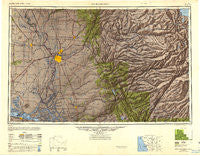
~ Sacramento CA topo map, 1:250000 scale, 1 X 2 Degree, Historical, 1947, updated 1948
Sacramento, California, USGS topographic map dated 1947.
Includes geographic coordinates (latitude and longitude). This topographic map is suitable for hiking, camping, and exploring, or framing it as a wall map.
Printed on-demand using high resolution imagery, on heavy weight and acid free paper, or alternatively on a variety of synthetic materials.
Topos available on paper, Waterproof, Poly, or Tyvek. Usually shipping rolled, unless combined with other folded maps in one order.
- Product Number: USGS-5506625
- Free digital map download (high-resolution, GeoPDF): Sacramento, California (file size: 14 MB)
- Map Size: please refer to the dimensions of the GeoPDF map above
- Weight (paper map): ca. 55 grams
- Map Type: POD USGS Topographic Map
- Map Series: HTMC
- Map Verison: Historical
- Cell ID: 68999
- Scan ID: 707563
- Imprint Year: 1948
- Woodland Tint: Yes
- Aerial Photo Year: 1945
- Survey Year: 1944
- Datum: NAD27
- Map Projection: Transverse Mercator
- Shaded Relief map: Yes
- Map published by United States Geological Survey
- Map published by United States Army Corps of Engineers
- Map published by United States Army
- Map Language: English
- Scanner Resolution: 508 dpi
- Map Cell Name: Sacramento
- Grid size: 1 X 2 Degree
- Date on map: 1947
- Map Scale: 1:250000
- Geographical region: California, United States
Neighboring Maps:
All neighboring USGS topo maps are available for sale online at a variety of scales.
Spatial coverage:
Topo map Sacramento, California, covers the geographical area associated the following places:
- Thornton - Fremont - McAvoy - Capitol City Recreational Vehicle and Mobile Home Park - Garden Valley - Gold Hill - Grizzly Flat - Trails End Mobile Home Park - Virginiatown - Jacobs Corner - Croft - Brentwood Park - Paloma - Twin Cities - Cranmore - Saint Andrews Village - Saxon - Poffenbergers Landing - Cunard - Marchant - Coyoteville - Willow Point - Britona (historical) - King Farms - Electra - Valdez - Soudan - Volcanoville - West Point - Tiger Lily - Algodon (historical) - Douds Landing - High Sierra Park - Town and Country Village - Bummerville - Yolo - Kettleman - Lakemont Pines - Pleasant Grove - Walnut Trailer Villa - Jesus Maria - Bethel Island - Villinger - Sucro - McCulloh - Millers Landing - Comstock Ranch - Highland Park - Carbondale - Kobe (historical) - Soapweed - Salsbury (historical) - Pokerville (historical) - Woodbridge - Mountain Ranch Subdivision - Camp Earnest - Darlington - Collinsville - New Chicago - Fourth Crossing - Cottonwood - Victor - Clarksburg - Broderick - Coffing - Quintette - Arden Town - Frenchtown - Riego - Travis Field - Clarksville - Ronda (historical) - Mokelumne Hill - Wilson - Long Barn - Park Village - Arno (historical) - Winterhaven Village - Dozier - Sabre City - Oak Creek Hills - Rocklin - Cornwall - Need - Chinatown (historical) - Marble Mountain - Tahoe Keys - Chaparral Heights - Spring Valley - Ponderosa Park - Arroz - Leonardi - Ambrose (historical) - North Placerville - Herald - Elverta - Vacaville Junction - Mayhew - Violet (historical) - Routier (historical)
- Map Area ID: AREA3938-122-120
- Northwest corner Lat/Long code: USGSNW39-122
- Northeast corner Lat/Long code: USGSNE39-120
- Southwest corner Lat/Long code: USGSSW38-122
- Southeast corner Lat/Long code: USGSSE38-120
- Northern map edge Latitude: 39
- Southern map edge Latitude: 38
- Western map edge Longitude: -122
- Eastern map edge Longitude: -120


