
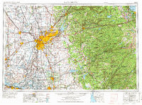
~ Sacramento CA topo map, 1:250000 scale, 1 X 2 Degree, Historical, 1957, updated 1972
Sacramento, California, USGS topographic map dated 1957.
Includes geographic coordinates (latitude and longitude). This topographic map is suitable for hiking, camping, and exploring, or framing it as a wall map.
Printed on-demand using high resolution imagery, on heavy weight and acid free paper, or alternatively on a variety of synthetic materials.
Topos available on paper, Waterproof, Poly, or Tyvek. Usually shipping rolled, unless combined with other folded maps in one order.
- Product Number: USGS-5506623
- Free digital map download (high-resolution, GeoPDF): Sacramento, California (file size: 23 MB)
- Map Size: please refer to the dimensions of the GeoPDF map above
- Weight (paper map): ca. 55 grams
- Map Type: POD USGS Topographic Map
- Map Series: HTMC
- Map Verison: Historical
- Cell ID: 68999
- Scan ID: 299861
- Imprint Year: 1972
- Woodland Tint: Yes
- Aerial Photo Year: 1960
- Edit Year: 1970
- Field Check Year: 1957
- Datum: Unstated
- Map Projection: Transverse Mercator
- Map published by: Military, Other
- Map Language: English
- Scanner Resolution: 600 dpi
- Map Cell Name: Sacramento
- Grid size: 1 X 2 Degree
- Date on map: 1957
- Map Scale: 1:250000
- Geographical region: California, United States
Neighboring Maps:
All neighboring USGS topo maps are available for sale online at a variety of scales.
Spatial coverage:
Topo map Sacramento, California, covers the geographical area associated the following places:
- Ponderosa Park - Fremont - Laguna - Fairbanks - Pearson - Ulatis Park - Sierra Village - Wyldewood - River Pines - Galt - Nielsburg - Happy Valley - Cambridge Oaks - Trails End Mobile Home Park - Goldmont Forest - Bridgehead - West Sacramento - Sunnybrook - Daisie - Phoenix Lake - Burson - Ewing - Wycoff (historical) - Dorrington - Thornton - Ranch House Estates - East Nicolaus - Strawberry - Elmira - Independence - Vanden (historical) - Violet (historical) - Fresh Pond - Green Springs Valley - Altaville - Sloughhouse - Cannon - Conaway - Pollock - Webster - Kilaga Springs - Sandy Gulch - Sucro - Tahoe Valley - Molena - Camino Heights - Sacramento - Malby Crossing - Big Trees Village - Cottage Springs - Winters - Yolo - Graham (historical) - Oxford - Vineyard - Zee Estates - King Farms - Spring Creek - Hams - Foppiano - Deadwood - Conley (historical) - Lilac Park - Sheldon - Plumtree (historical) - Upper Forni - Cedar Rock Lodge - Claussenius - Big Bar - Bryte - Town and Country Village - Arcade - Bullard - Tahoe Keys - Timber Trails - Nebelhorn - Irishtown (historical) - Rancho Yolo Mobile Home Park - Balderson Station - Lakeridge Oaks - Rosemont - Rocky Hill - Bethel Island - Fisher Place - Rocklin - Spring Valley - Camanche Village - McConnel Place - Meyers - Camp Pendola - Hidden Valley - Madison - Springfield - Old Pino - Alder Creek - Bellota - Hood Junction - Confidence - Dutton - Clarksburg
- Map Area ID: AREA3938-122-120
- Northwest corner Lat/Long code: USGSNW39-122
- Northeast corner Lat/Long code: USGSNE39-120
- Southwest corner Lat/Long code: USGSSW38-122
- Southeast corner Lat/Long code: USGSSE38-120
- Northern map edge Latitude: 39
- Southern map edge Latitude: 38
- Western map edge Longitude: -122
- Eastern map edge Longitude: -120


