
~ Sacramento CA topo map, 1:250000 scale, 1 X 2 Degree, Historical, 1957, updated 1972
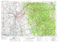
Sacramento, California, USGS topographic map dated 1957.
Includes geographic coordinates (latitude and longitude). This topographic map is suitable for hiking, camping, and exploring, or framing it as a wall map.
Printed on-demand using high resolution imagery, on heavy weight and acid free paper, or alternatively on a variety of synthetic materials.
Topos available on paper, Waterproof, Poly, or Tyvek. Usually shipping rolled, unless combined with other folded maps in one order.
- Product Number: USGS-5506621
- Free digital map download (high-resolution, GeoPDF): Sacramento, California (file size: 22 MB)
- Map Size: please refer to the dimensions of the GeoPDF map above
- Weight (paper map): ca. 55 grams
- Map Type: POD USGS Topographic Map
- Map Series: HTMC
- Map Verison: Historical
- Cell ID: 68999
- Scan ID: 299859
- Imprint Year: 1972
- Woodland Tint: Yes
- Visual Version Number: 1
- Aerial Photo Year: 1960
- Edit Year: 1970
- Field Check Year: 1957
- Datum: Unstated
- Map Projection: Transverse Mercator
- Map published by: Military, Other
- Map Language: English
- Scanner Resolution: 600 dpi
- Map Cell Name: Sacramento
- Grid size: 1 X 2 Degree
- Date on map: 1957
- Map Scale: 1:250000
- Geographical region: California, United States
Neighboring Maps:
All neighboring USGS topo maps are available for sale online at a variety of scales.
Spatial coverage:
Topo map Sacramento, California, covers the geographical area associated the following places:
- Dutton - Sunset Mobile Home Park - Clarsona - Centralia - Olcott - Courtland - Lakewood Park - Quintette - Rocklin - Skylark Mobile Home Park - Camino Heights - Oak Ridge Village - Chaparral Heights - Del Paso - Rancho Calaveras - Manzanita Acres - Skinners - Omo Ranch - Jacobs Corner - Easton Place - Green Springs Ranch - Leisure Town - Tamarack Springs - Millertown (historical) - Denverton - Fort Jones - Dougherty - Canyon View - Sugarpine - Maine Prairie - Wilton - Pleasant Valley - Crescent Ridge Village - Oak Tree Village - Emerald Bay - Michigan Bar (historical) - Sweeneys Crossing - Youngstown - Shaws Flat - Soudan - Vallecito - Morrison - Oak Creek Hills - Ronda (historical) - Milligan District (historical) - Volcano - Todd Valley - Collinsville - Old Pino - Brandon Corner - Rio Vista Junction - Arcade - Rail Road Flat - Binghamton - Folsom - Ben Ali - Cherokee - Cannon - Folsom Junction - Norton - Cambridge Oaks - Altaville - Buckeye - Little Norway - Rosemont - McAvoy - Cornelius (historical) - El Rio Villa - Bethel Island - Ewing - Grizzly Peak - Jones Place - Wilseyville - Bunker - Zee Estates - Amador City - Poffenbergers Landing - McCulloh - Kelsey - La Riviera - East Side - Bryants - Mother Lode Acres - Saxon - Birds Landing - Sugarfield - Camden - Roma - Marina Village - Perkins - Ambrose (historical) - McKay - Phoenix Lake - Bellota - Vorden - Forest Home (historical) - Columbia Village - Kettleman - Malby Crossing - Jayhawk
- Map Area ID: AREA3938-122-120
- Northwest corner Lat/Long code: USGSNW39-122
- Northeast corner Lat/Long code: USGSNE39-120
- Southwest corner Lat/Long code: USGSSW38-122
- Southeast corner Lat/Long code: USGSSE38-120
- Northern map edge Latitude: 39
- Southern map edge Latitude: 38
- Western map edge Longitude: -122
- Eastern map edge Longitude: -120


