
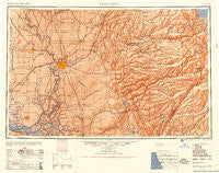
~ Sacramento CA topo map, 1:250000 scale, 1 X 2 Degree, Historical, 1956, updated 1956
Sacramento, California, USGS topographic map dated 1956.
Includes geographic coordinates (latitude and longitude). This topographic map is suitable for hiking, camping, and exploring, or framing it as a wall map.
Printed on-demand using high resolution imagery, on heavy weight and acid free paper, or alternatively on a variety of synthetic materials.
Topos available on paper, Waterproof, Poly, or Tyvek. Usually shipping rolled, unless combined with other folded maps in one order.
- Product Number: USGS-5506613
- Free digital map download (high-resolution, GeoPDF): Sacramento, California (file size: 17 MB)
- Map Size: please refer to the dimensions of the GeoPDF map above
- Weight (paper map): ca. 55 grams
- Map Type: POD USGS Topographic Map
- Map Series: HTMC
- Map Verison: Historical
- Cell ID: 68999
- Scan ID: 299855
- Imprint Year: 1956
- Aerial Photo Year: 1945
- Datum: NAD27
- Map Projection: Transverse Mercator
- Shaded Relief map: Yes
- Map published by United States Army Corps of Engineers
- Map published by United States Army
- Map Language: English
- Scanner Resolution: 600 dpi
- Map Cell Name: Sacramento
- Grid size: 1 X 2 Degree
- Date on map: 1956
- Map Scale: 1:250000
- Geographical region: California, United States
Neighboring Maps:
All neighboring USGS topo maps are available for sale online at a variety of scales.
Spatial coverage:
Topo map Sacramento, California, covers the geographical area associated the following places:
- Elvas - Mother Lode Acres - Quail Oaks - East Nicolaus - Lincoln Village - Shore Acres - Fuchs - Indak (historical) - Howard Landing - Darlington - Wycoff (historical) - Hebron (historical) - Manuel Mill - Phoenix Lake County Club Estates - Marina Village - Sierra Springs - Walerga - Salsbury (historical) - Woodlake - Woodbridge - North Highlands - Hidden Valley - Snowshoe Springs - Koloma (historical) - Paloma - Twain Harte - Coloma - Rancho Yolo Mobile Home Park - Little Norway - Bonnefoy - East Sacramento - Winterhaven Village - Phillips - Acampo - Elvaton (historical) - Cornelius (historical) - Jesus Maria - Gold River - Molena - Scottsville - Collierville - Cordova - Routier (historical) - Sunset Mobile Home Park - Zee Estates - Kirkwood - Maine Prairie - Alabama Hill - Enterprise - Urgon - Lilac Park - Bummerville - Ramona - Riego - Henderson Village - Ulatis Park - Swanston - Ronda (historical) - Griminger - Norton - Walnut Trailer Villa - Lakeshore - Dogtown - Clayton - Hershey - Sheep Ranch - Clay - Skylark Mobile Home Park - Lodi - Clipper Gap - Ganns - Dunnigan - Diamond - Avinsino Corner - Golden Torch Trailer Park - Georgetown - Black Oak Estates - Millers Landing - El Macero - Jupiter - Murphys - Vacaville Junction - Binghamton - Violet (historical) - Allendale - Carmen City - Lakemont Pines - Rancho Calaveras - Campo Seco - Carson Hill - Cedar Ridge - Joes Landing - Outingdale - Aukum - Happy Valley - Hood - Pope - Green - Arnold - Point Pleasant
- Map Area ID: AREA3938-122-120
- Northwest corner Lat/Long code: USGSNW39-122
- Northeast corner Lat/Long code: USGSNE39-120
- Southwest corner Lat/Long code: USGSSW38-122
- Southeast corner Lat/Long code: USGSSE38-120
- Northern map edge Latitude: 39
- Southern map edge Latitude: 38
- Western map edge Longitude: -122
- Eastern map edge Longitude: -120


