
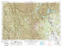
~ Redding CA topo map, 1:250000 scale, 1 X 2 Degree, Historical, 1958, updated 1977
Redding, California, USGS topographic map dated 1958.
Includes geographic coordinates (latitude and longitude). This topographic map is suitable for hiking, camping, and exploring, or framing it as a wall map.
Printed on-demand using high resolution imagery, on heavy weight and acid free paper, or alternatively on a variety of synthetic materials.
Topos available on paper, Waterproof, Poly, or Tyvek. Usually shipping rolled, unless combined with other folded maps in one order.
- Product Number: USGS-5506611
- Free digital map download (high-resolution, GeoPDF): Redding, California (file size: 29 MB)
- Map Size: please refer to the dimensions of the GeoPDF map above
- Weight (paper map): ca. 55 grams
- Map Type: POD USGS Topographic Map
- Map Series: HTMC
- Map Verison: Historical
- Cell ID: 75008
- Scan ID: 299853
- Imprint Year: 1977
- Woodland Tint: Yes
- Aerial Photo Year: 1975
- Edit Year: 1976
- Field Check Year: 1958
- Datum: Unstated
- Map Projection: Transverse Mercator
- Map published by: Military, Other
- Map Language: English
- Scanner Resolution: 600 dpi
- Map Cell Name: Redding
- Grid size: 1 X 2 Degree
- Date on map: 1958
- Map Scale: 1:250000
- Geographical region: California, United States
Neighboring Maps:
All neighboring USGS topo maps are available for sale online at a variety of scales.
Spatial coverage:
Topo map Redding, California, covers the geographical area associated the following places:
- Hammer Place - Tunnel Inn - Keswick - Riverside - Whitethorn - Shady Hill Trailer Park - Paradise View Mobile Estates - Bayles Place - Kettenpom - Wigdon Place - Dinsmore - Riviera Mobile Estates - Ridgeville - Lakeview Resort - Blue Lake - Dales - Buckeye - Lillienthal (historical) - Whitlow - Moose-horn Mobile Home Park - Pete Hoff Place - Zenia - French Gulch - Shively - Ono - Tehama - Crabtree Place - Cold Fork - Hooker - Fernwood - Steelhead - Beall Place - Briceland - Banfield Place - Bucktail - Government Camp - Twin Lakes Mobile Estates - Gas Point - Holiday Harbor Resort - Lone Star Junction - Palo Cedro - Kett - Summit City (historical) - Iron Mountain - El Camino - Furnaceville (historical) - Motion - Pine Grove - Wildwood - Norgaar (historical) - O'Brien - Ettersburg - Wagoner - Eel Rock - Twin View Terrace Mobile Home Park - McCann - Payne - Westend Galatin Place (historical) - Estrellita - Shady Oaks Mobile Park - Cottonwood - Dinsmores - Shasta Lake Mobile Home Park - Yager Junction - Starlite Mobile Estates - Waugh (historical) - Marina Travel Park - Riverside Mobile Park - Ydaloom (historical) - Larabee - Benbow - Red Bluff - Proberta - Keno (historical) - Balls Ferry Fishing Resort - Mountain Gate - Blunt - Leonard Place (historical) - Willie Hoaglin Place - Skinner Mill Place - Country Club Mobile Estates - Wonderland Mobile Home Park - Gerber - Baird (historical) - Lamoine - Mad River - Willow Creek - Amberwood Mobile Home Park - Rosewood - Bob Hoaglin Place - Girvan - Cedar Stock - Mabel (historical) - Deluxe Mobile Park - Osborne - Los Robles Estates - Russ Place - Paige Bar - Murphy Place - Olinda
- Map Area ID: AREA4140-124-122
- Northwest corner Lat/Long code: USGSNW41-124
- Northeast corner Lat/Long code: USGSNE41-122
- Southwest corner Lat/Long code: USGSSW40-124
- Southeast corner Lat/Long code: USGSSE40-122
- Northern map edge Latitude: 41
- Southern map edge Latitude: 40
- Western map edge Longitude: -124
- Eastern map edge Longitude: -122


