
~ Redding CA topo map, 1:250000 scale, 1 X 2 Degree, Historical, 1958, updated 1965
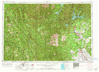
Redding, California, USGS topographic map dated 1958.
Includes geographic coordinates (latitude and longitude). This topographic map is suitable for hiking, camping, and exploring, or framing it as a wall map.
Printed on-demand using high resolution imagery, on heavy weight and acid free paper, or alternatively on a variety of synthetic materials.
Topos available on paper, Waterproof, Poly, or Tyvek. Usually shipping rolled, unless combined with other folded maps in one order.
- Product Number: USGS-5506609
- Free digital map download (high-resolution, GeoPDF): Redding, California (file size: 25 MB)
- Map Size: please refer to the dimensions of the GeoPDF map above
- Weight (paper map): ca. 55 grams
- Map Type: POD USGS Topographic Map
- Map Series: HTMC
- Map Verison: Historical
- Cell ID: 75008
- Scan ID: 299852
- Imprint Year: 1965
- Woodland Tint: Yes
- Edit Year: 1964
- Field Check Year: 1958
- Datum: Unstated
- Map Projection: Transverse Mercator
- Map published by United States Army Corps of Engineers
- Map published by United States Army
- Map Language: English
- Scanner Resolution: 600 dpi
- Map Cell Name: Redding
- Grid size: 1 X 2 Degree
- Date on map: 1958
- Map Scale: 1:250000
- Geographical region: California, United States
Neighboring Maps:
All neighboring USGS topo maps are available for sale online at a variety of scales.
Spatial coverage:
Topo map Redding, California, covers the geographical area associated the following places:
- Watson - Fernwood - Pinewood Cove - Brookside Mobile Home Park - Westend Galatin Place (historical) - Sugarloaf - Banfield Place - Paradise View Mobile Estates - Olinda - Newtown - Pollock - Cooks Valley - Proberta - Minersville (historical) - Hogtown (historical) - Paige Bar - Steelhead - Estrellita - Trinity Center - Luckie Place - Bragdon (historical) - Kiska - Girvan - Bella Vista - Cottonwood Estates - Bucktail - Larabee - Miller Place - Lazy Landing Mobile Home Park - Cain Rock - Bramlet Place - Ellis (historical) - Wigdon Place - Sids Place - Buckeye - McColl - Swain Place - Silverthorn - Bayles Place - Dales - Enterprise - Pepperwood - Country Club Mobile Estates - French Gulch - Pine Grove - Beegum - Lakeshore - Hammer Place - Lone Star Junction - Beall Place - Penney - Mad River - Riverside Park - Starlite Mobile Estates - Bend - McClellan Place - Middletown (historical) - Bob Hoaglin Place - Iron Mountain - Shady Acres Trailer Park - Dedrick - Ydaloom (historical) - Myers Flat - Maple Creek - Shively - Calkins (historical) - Red Bank - Safari Mobile Home Park - Red Bluff - Knob - Mountain Shadows Mobile Home Estates - Henryford (historical) - Redding Lakeside Mobile Estates - Hatfield Place (historical) - Twin View Terrace Mobile Home Park - Dinsmores - Oak Bottom (historical) - Pete Hoff Place - Norgaar (historical) - Montgomery Place - Haven Place - Gilliam Place - Whitlow - Pollard Flat - Shady Hill Trailer Park - Fort Seward - Skinner Mill Place - Whiskeytown - Clear Creek Mobile Home Park - Portal Inn - Blue Lake - Peanut - Smith (historical) - Englewood - Brock Creek (historical) - Burnt Ranch - Redwoods Mobile Home Community - Lakeview Resort - Amberwood Mobile Home Park - Dairyville
- Map Area ID: AREA4140-124-122
- Northwest corner Lat/Long code: USGSNW41-124
- Northeast corner Lat/Long code: USGSNE41-122
- Southwest corner Lat/Long code: USGSSW40-124
- Southeast corner Lat/Long code: USGSSE40-122
- Northern map edge Latitude: 41
- Southern map edge Latitude: 40
- Western map edge Longitude: -124
- Eastern map edge Longitude: -122


