
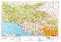
~ Los Angeles CA topo map, 1:250000 scale, 1 X 2 Degree, Historical, 1959, updated 1969
Los Angeles, California, USGS topographic map dated 1959.
Includes geographic coordinates (latitude and longitude). This topographic map is suitable for hiking, camping, and exploring, or framing it as a wall map.
Printed on-demand using high resolution imagery, on heavy weight and acid free paper, or alternatively on a variety of synthetic materials.
Topos available on paper, Waterproof, Poly, or Tyvek. Usually shipping rolled, unless combined with other folded maps in one order.
- Product Number: USGS-5506573
- Free digital map download (high-resolution, GeoPDF): Los Angeles, California (file size: 23 MB)
- Map Size: please refer to the dimensions of the GeoPDF map above
- Weight (paper map): ca. 55 grams
- Map Type: POD USGS Topographic Map
- Map Series: HTMC
- Map Verison: Historical
- Cell ID: 68882
- Scan ID: 299818
- Imprint Year: 1969
- Woodland Tint: Yes
- Edit Year: 1968
- Field Check Year: 1959
- Datum: Unstated
- Map Projection: Transverse Mercator
- Map published by United States Army Corps of Engineers
- Map published by United States Army
- Map Language: English
- Scanner Resolution: 600 dpi
- Map Cell Name: Los Angeles
- Grid size: 1 X 2 Degree
- Date on map: 1959
- Map Scale: 1:250000
- Geographical region: California, United States
Neighboring Maps:
All neighboring USGS topo maps are available for sale online at a variety of scales.
Spatial coverage:
Topo map Los Angeles, California, covers the geographical area associated the following places:
- Gorman - Bouquet Junction - Willow Springs - Sulphur Springs - Irma - Panorama City - Hollywood Heights - Old Town - East Arcadia - Montalvo - Ninth Street Junction - El Monte - Lake Balboa - Casitas Springs - Agoura Hills - Rancho Vista - Lake View Terrace - El Dorada Mobile Estates - Brentwood Park - Gemco - West Los Angeles - Casa del Norte Mobile Home Community - Happy Valley - Mussel Shoals - Sycamore Cove - La Quinta - Topanga Oaks - City Terrace - Belvedere - Vega - Ravenna - Lamplighter Mobile Home Park - Pacific Palisades - Grapevine - Mission - Toro Canyon - North Fillmore - Del Valle - Carpinteria - South El Monte - Monte Nido - Solromar - Sherman Oaks - Brentwood - Crescent - Castellammare - Montebello - Ojai - La Cañada Flintridge - Naylor Place - Highway Highlands - Ninetynine Oaks - Whittier Junction - Serena Park - Wildwood - Caswell - Matilija - Chandler (historical) - The Colony Mobile Home Park - Los Angeles - Seminole Hot Springs - Camp Bartlett - Jefferson - Sierra Vista - Malibu Hills - Golden Oaks Mobile Estates - Rincon - Chatsworth - Valencia - Cuyama - Ortonville - Sepulveda - Seminole Springs Trailer Park - Forest Park - Solemint - Paris - Universal City - Hope Ranch - Savannah (historical) - Maxson - Glenview - Casitas Mobile Home Park - Boiling Point - Pearland - Aliso Village - Lakeview - Lincoln Heights - East Pasadena - Santa Maria - Oxnard Shores - Isla Vista - Palms - Hobart - Highland Park - Rosamond - Inceville - Malibu Junction - Martins - Hollywood by the Sea - Dayton Avenue
- Map Area ID: AREA3534-120-118
- Northwest corner Lat/Long code: USGSNW35-120
- Northeast corner Lat/Long code: USGSNE35-118
- Southwest corner Lat/Long code: USGSSW34-120
- Southeast corner Lat/Long code: USGSSE34-118
- Northern map edge Latitude: 35
- Southern map edge Latitude: 34
- Western map edge Longitude: -120
- Eastern map edge Longitude: -118


