
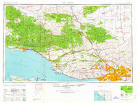
~ Los Angeles CA topo map, 1:250000 scale, 1 X 2 Degree, Historical, 1959
Los Angeles, California, USGS topographic map dated 1959.
Includes geographic coordinates (latitude and longitude). This topographic map is suitable for hiking, camping, and exploring, or framing it as a wall map.
Printed on-demand using high resolution imagery, on heavy weight and acid free paper, or alternatively on a variety of synthetic materials.
Topos available on paper, Waterproof, Poly, or Tyvek. Usually shipping rolled, unless combined with other folded maps in one order.
- Product Number: USGS-5506565
- Free digital map download (high-resolution, GeoPDF): Los Angeles, California (file size: 16 MB)
- Map Size: please refer to the dimensions of the GeoPDF map above
- Weight (paper map): ca. 55 grams
- Map Type: POD USGS Topographic Map
- Map Series: HTMC
- Map Verison: Historical
- Cell ID: 68882
- Scan ID: 299814
- Woodland Tint: Yes
- Aerial Photo Year: 1944
- Datum: NAD27
- Map Projection: Transverse Mercator
- Map published by United States Army Corps of Engineers
- Map published by United States Army
- Map Language: English
- Scanner Resolution: 600 dpi
- Map Cell Name: Los Angeles
- Grid size: 1 X 2 Degree
- Date on map: 1959
- Map Scale: 1:250000
- Geographical region: California, United States
Neighboring Maps:
All neighboring USGS topo maps are available for sale online at a variety of scales.
Spatial coverage:
Topo map Los Angeles, California, covers the geographical area associated the following places:
- Valencia - Old Town - Oxnard Shores - Brooklyn Heights - West Los Angeles - North Fillmore - Newton Park - Honby - Temple City - El Sueno - Greenwich Village - Oak Park - Hewitt - Sunrise - Atwater - Lafayette Square - Lake Hughes - Panorama City - Montebello - Wene'me (historical) - Fern Ann Falls - Briggs Terrace - Martins - Camarillo Mobile Estates - Wellington Heights - Sandpiper Mobile Home Park - Boston Heights - Winter Gardens - Agua Dulce - Channel Islands Beach - Topanga Oaks - Oak Knoll - Ninetynine Oaks - Mussel Shoals - Ventucopa - Chatsworth - Lakeview - Brownstone (historical) - Tejon Ranch - Sulphur Springs - Del Sur - Santa Monica - Rancho Granada Mobile Homes - Malibu Vista - Shorb - West Hollywood - Paris - Woodland Hills - South San Gabriel - Orchams - Chrisman - El Nido - Maravilla - Kevet - Sunland - Friendly Village Mobile Home Park - Winnetka - Beverly Glen - Ramona Park - Pasadena - Westwood Village - Cienega - Malibu Junction - Pine Mountain Club - Vickers Hot Springs - Los Angeles - Pardee - Saticoy - Three Points - Canoga Park - Ojai - North Ranch - Harold - Carthay Square - New Chinatown - Garnsey - Montecito - Mahou Riviera - Waltz - Hollywood Beach - Seminole Springs Trailer Park - Franciscan Village - Holland Summit (historical) - Aurant - Alpine - Reseda - Sulphur Springs - Old Town - Kagel Canyon - Harvard Heights - La Conchita - Sucrosa (historical) - Sandyland Cove - Sandyland - Elayon - Buckhorn - Mar Vista - Antelope Acres - Cachuma Village - Eastmont
- Map Area ID: AREA3534-120-118
- Northwest corner Lat/Long code: USGSNW35-120
- Northeast corner Lat/Long code: USGSNE35-118
- Southwest corner Lat/Long code: USGSSW34-120
- Southeast corner Lat/Long code: USGSSE34-118
- Northern map edge Latitude: 35
- Southern map edge Latitude: 34
- Western map edge Longitude: -120
- Eastern map edge Longitude: -118


