
~ Long Beach CA topo map, 1:250000 scale, 1 X 2 Degree, Historical, 1957, updated 1979
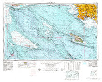
Long Beach, California, USGS topographic map dated 1957.
Includes geographic coordinates (latitude and longitude). This topographic map is suitable for hiking, camping, and exploring, or framing it as a wall map.
Printed on-demand using high resolution imagery, on heavy weight and acid free paper, or alternatively on a variety of synthetic materials.
Topos available on paper, Waterproof, Poly, or Tyvek. Usually shipping rolled, unless combined with other folded maps in one order.
- Product Number: USGS-5506563
- Free digital map download (high-resolution, GeoPDF): Long Beach, California (file size: 23 MB)
- Map Size: please refer to the dimensions of the GeoPDF map above
- Weight (paper map): ca. 55 grams
- Map Type: POD USGS Topographic Map
- Map Series: HTMC
- Map Verison: Historical
- Cell ID: 68880
- Scan ID: 299813
- Imprint Year: 1979
- Woodland Tint: Yes
- Aerial Photo Year: 1977
- Edit Year: 1978
- Field Check Year: 1957
- Datum: Unstated
- Map Projection: Transverse Mercator
- Map published by United States Geological Survey
- Map published by United States Department of Commerce
- Map Language: English
- Scanner Resolution: 600 dpi
- Map Cell Name: Long Beach
- Grid size: 1 X 2 Degree
- Date on map: 1957
- Map Scale: 1:250000
- Geographical region: California, United States
Neighboring Maps:
All neighboring USGS topo maps are available for sale online at a variety of scales.
Spatial coverage:
Topo map Long Beach, California, covers the geographical area associated the following places:
- Workman - Hyde Park - Bluff Heights - Hollywood Riviera - Rio Hondo - La Fresa - Moneta - Morningside Park - La Mirada - Westchester - Palos Verdes Peninsula - Ironsides - Lincoln Village - Sea Aria East Mobile Home Estates - Roosevelt - Rancho Palos Verdes - Alsace - Miraleste - Hyperion (historical) - Rolling Hills - California Heights - Dudmore - Wrigley - Compton - Artesia - Lynwood Gardens - Los Altos - El Segundo - Lennox - Studebaker - Douglas Junction - View Park - Fulton Wells - Athens - Marina del Rey - Cypress - Nickerson Gardens - Paramount - Cambodia Town - Morton - Hollydale - Alondra Park - Del Ray - Lincoln Center Mobile Home Park - Bluff Park - Los Nietos - Leisure World - East Rancho Dominguez - Imperial Courts - Beachview Mobile Home Park - Laguna - McCampbell - Holton (historical) - Long Beach - Motordrome (historical) - Florence - Dolanco Junction - Hawaiian Gardens - Portuguese Bend - Cota - South Los Angeles - Friendly Hills - Pico Rivera - Playa del Rey - Cudahy - Two Harbors - Valla - Rose Park - Dolores - Harbor Hills - Clearwater - El Nido - Seal Beach Trailer Park - West Whittier - Bandini - Los Alisos Mobile Home Estates - Avalon Village - La Palma - Huntington Park - Watts - Seal Beach - Rossmoor - El Rancho Mobile Home Park - South Whittier - Cypave - Bingham - Cerritos - Windsor Hills - Monaco - Elftman - West Rancho Dominguez - Los Nietos Junction - Vista del Mar - Lomita - Willowbrook - Bridgedale - Walker - Avalon - Bellflower - Los Robles Mobile Home Park
- Map Area ID: AREA3433-120-118
- Northwest corner Lat/Long code: USGSNW34-120
- Northeast corner Lat/Long code: USGSNE34-118
- Southwest corner Lat/Long code: USGSSW33-120
- Southeast corner Lat/Long code: USGSSE33-118
- Northern map edge Latitude: 34
- Southern map edge Latitude: 33
- Western map edge Longitude: -120
- Eastern map edge Longitude: -118


