
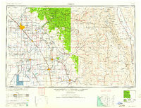
~ Fresno CA topo map, 1:250000 scale, 1 X 2 Degree, Historical, 1960, updated 1960
Fresno, California, USGS topographic map dated 1960.
Includes geographic coordinates (latitude and longitude). This topographic map is suitable for hiking, camping, and exploring, or framing it as a wall map.
Printed on-demand using high resolution imagery, on heavy weight and acid free paper, or alternatively on a variety of synthetic materials.
Topos available on paper, Waterproof, Poly, or Tyvek. Usually shipping rolled, unless combined with other folded maps in one order.
- Product Number: USGS-5506551
- Free digital map download (high-resolution, GeoPDF): Fresno, California (file size: 16 MB)
- Map Size: please refer to the dimensions of the GeoPDF map above
- Weight (paper map): ca. 55 grams
- Map Type: POD USGS Topographic Map
- Map Series: HTMC
- Map Verison: Historical
- Cell ID: 68792
- Scan ID: 299771
- Imprint Year: 1960
- Woodland Tint: Yes
- Aerial Photo Year: 1944
- Datum: Unstated
- Map Projection: Transverse Mercator
- Map published by United States Army Corps of Engineers
- Map published by United States Army
- Map Language: English
- Scanner Resolution: 600 dpi
- Map Cell Name: Fresno
- Grid size: 1 X 2 Degree
- Date on map: 1960
- Map Scale: 1:250000
- Geographical region: California, United States
Neighboring Maps:
All neighboring USGS topo maps are available for sale online at a variety of scales.
Spatial coverage:
Topo map Fresno, California, covers the geographical area associated the following places:
- Kearsarge - Waukena - Glorietta - Rayo - Silver City - Orion (historical) - Hume - Toolville - East Porterville - Armona - Fane - Dunlap - West Park - Auckland - Primero (historical) - Quail - Malaga - Mirador - Selma - Cutler - Riverdale - Harmony - Orange Cove - Guernsey - Citro - Springville - Bowles - Sides (historical) - Hasset (historical) - Pratton - Traver - Tokay - Shell - Stratford - San Joaquin River Estates - Sultana - Hammond - Naranjo - North Dinuba - Fort Camp (historical) - Cabin Cove - Westhaven - Orlem (historical) - Fig Garden - McKenzie Spring (historical) - Antes - Ivanhoe - Hammond - Tagus - South Corcoran - Burness - Kings Mobile Home Estates - Lillis (historical) - Hub - Rodgers Crossing - Kaweah - Hoffman Point - Jones Corner - Blanco - Lanare - Cairns Corner - Ponderosa - Camden - Melvin - Ponca - Oleander - Biola Junction - Hartland - Trigo - Minkler - Ivesta - McMullin (historical) - Clint - Alfac (historical) - Letcher (historical) - Wilsonia - Twin Buttes - Cecile - Yokohl - Pitco - Worth - Stony Creek Village - Whitley Manor Mobile Home Park - Exeter - Woodville - Lethent (historical) - Grant Grove Village - Clovis - Mitchell Corner - Cameo - Magnolia - Stout - Burling (historical) - Shipp (historical) - Yettem - Potwisha - Wolf - Irrigosa - Corcoran - Las Palmas
- Map Area ID: AREA3736-120-118
- Northwest corner Lat/Long code: USGSNW37-120
- Northeast corner Lat/Long code: USGSNE37-118
- Southwest corner Lat/Long code: USGSSW36-120
- Southeast corner Lat/Long code: USGSSE36-118
- Northern map edge Latitude: 37
- Southern map edge Latitude: 36
- Western map edge Longitude: -120
- Eastern map edge Longitude: -118


