
~ Crescent City CA topo map, 1:250000 scale, 1 X 2 Degree, Historical, 1958, updated 1978
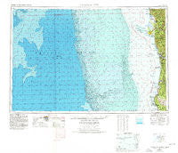
Crescent City, California, USGS topographic map dated 1958.
Includes geographic coordinates (latitude and longitude). This topographic map is suitable for hiking, camping, and exploring, or framing it as a wall map.
Printed on-demand using high resolution imagery, on heavy weight and acid free paper, or alternatively on a variety of synthetic materials.
Topos available on paper, Waterproof, Poly, or Tyvek. Usually shipping rolled, unless combined with other folded maps in one order.
- Product Number: USGS-5506517
- Free digital map download (high-resolution, GeoPDF): Crescent City, California (file size: 26 MB)
- Map Size: please refer to the dimensions of the GeoPDF map above
- Weight (paper map): ca. 55 grams
- Map Type: POD USGS Topographic Map
- Map Series: HTMC
- Map Verison: Historical
- Cell ID: 68733
- Scan ID: 299749
- Imprint Year: 1978
- Woodland Tint: Yes
- Aerial Photo Year: 1975
- Edit Year: 1977
- Datum: Unstated
- Map Projection: Transverse Mercator
- Map published by United States Geological Survey
- Map Language: English
- Scanner Resolution: 600 dpi
- Map Cell Name: Crescent City
- Grid size: 1 X 2 Degree
- Date on map: 1958
- Map Scale: 1:250000
- Geographical region: California, United States
Neighboring Maps:
All neighboring USGS topo maps are available for sale online at a variety of scales.
Spatial coverage:
Topo map Crescent City, California, covers the geographical area associated the following places:
- Shumig (historical) - Ore'q (historical) - Westhaven - Hoppaw - Klamath - Trinidad - Elk Grove (historical) - Berry Glenn - Crannell - Hiouchi - Yontocket - Tatlatunne (historical) - False Klamath - Khwunrghunme (historical) - Waukell Flat (historical) - Smith River - Requa - Camp Klamath - Patricks Point - Fort Dick - Orick - Crescent City - Moonstone - Khoonkhwuttunne (historical) - Big Lagoon - Tsurau (historical) - Tryon Corner - Rekwoi (historical) - Pacific Shores - Douglas Park
- Map Area ID: AREA4241-126-124
- Northwest corner Lat/Long code: USGSNW42-126
- Northeast corner Lat/Long code: USGSNE42-124
- Southwest corner Lat/Long code: USGSSW41-126
- Southeast corner Lat/Long code: USGSSE41-124
- Northern map edge Latitude: 42
- Southern map edge Latitude: 41
- Western map edge Longitude: -126
- Eastern map edge Longitude: -124


